Preamble
In an attempt to further reduce the digital burden, I acquired some dice to replace random number generator websites. The first roll of these new analogue catapults decreed that I would go grid square G7. This square, located to the North East of the city centre, contains most of the suburb of Chesterton, an area that had been developed during the 1930s and the post war period for municipal and council housing. The parish of Chesterton was administratively subsumed into Cambridge in the early 20th century as the former agricultural land, around what had been a village, was developed. To the North West of G7, Milton Road severs Chesterton from an area mostly unbuilt on and showing as a green space at the time of the 1980 map.
The Chesterton part of the map covered an area I was fairly familiar with, at least in part. But it was the streets I had no recollection of having ever been down, or in some cases never heard of at all, that intrigued me the most. I was familiar with Scotland Road, but not so much the streets that branched off from it. In particular, the cluster of streets named after places north of the border were an unknown quantity. Edinburgh Road, Inverness Close and Stirling Close were only barely on the periphery of my mental map. I wondered, what was the Scottish connection? North of these streets the map depicts an allotment. This space was a blind spot in my mental geography of Cambridge. I wondered if the allotments were still there or had been lost to development in the intervening years. Further to the North, in a corner between Milton Road and Green End Road, the map depicts a recreation ground. This was another blind spot. Despite having cycled along the adjacent Green end Road countless times, I had never noticed any entrance to any rec.
In the North Western part of the grid square, somewhere in the large green space that stretched behind the back gardens of houses on, was the site of a former anthrax burial. The map shows an athletics track creeping into square C7 at the western extremity of this space, likely party of the Manor secondary school playing fields. I knew that most of this green area was now largely covered by houses and flats. A friend told me he had heard some travellers were evicted from the site at some point before this, the anthrax contamination being cited by the authorities as making it unsafe for them to stay. Shortly afterwards, the new housing estate was built. The depiction of this area on the map as a largely featureless green space and these possibly unreliable snippets of its history sparked my imagination.

Amble
I crossed the border into Grid Square G7 at the confluence of Water Lane, Water Street and Fallowfield. Fallowfield is the name of a street and the residential area in its immediate environs that was first developed as ‘assisted’ housing in the 1930s. Presumably the space was one of the fields of Chesterton prior to its development. I had vague memories of visiting the area in the 1990s to house parties once or twice. But so vague that when I passed the cheery floral sign, reminiscent of something from a 1970s primary school, I may as well have been stepping across the border into a different time and space.

The street was familiar yet unfamiliar. Superficially, I could have been in a late 1930s municipal suburb of any town. But there was a particular atmosphere permeating from the houses, grass verges, passages and front garden paraphernalia that comprised the physical environment. It was something peculiar to Chesterton, in particular the part developed in the late 1930s as municipal housing that I had (must have) felt before. It probably harked back to my earliest memories of Chesterton as a small boy, when visiting my uncle, aunt and cousins who lived on Cam Causeway.
Where the road split in each direction and circled around
some houses on a sort of large residential roundabout, I took the longest arc,
passing a profusion of front gardens and some newer residential developments
mixed in with the older houses. Soon I came to a dead end (for drivers) where
there was a car park, strictly for residents. For the pedestrian, there was a
passage leading to Franks Lane, a street I had never been down. The crack along the middle of the asphalt of the first half of the passage made it look like an underground watercourse was straining to get through and would soon be successful.

The short distance through the passage was enough to disorientate me. As I stepped out of the other end, I mistakenly thought I’d emerged into Cam Causeway. Such was the similarity to the street my cousins used to live in. I realised after checking the map, that Cam Causeway ran parallel, just beyond the back gardens of the houses I now faced. I walked down the end of Franks Lane to find another passage, one shown on the map connecting the two streets. I was pleased to find it still existed, but I did not pass beyond the post that marked both the passage entrance and the boundary between grid squares. At this point I realised that the festival of Terminalia, God of Boundaries and Borders, was the following day. From that point the walk took on a different dimension. The various borders, boundaries and landmarks I passed by all made their presence felt, as if they were ‘manifestations’ of Terminus. I decided to mark the occasion early since work the next day would interfere with any proper attempt to do so. I say I decided, but it felt as if the various physically inanimate boundary markers and landmarks I encountered along the way were semi-sentient guides that compelled me to notice them above all else.

I doubled back and turned out of Franks Lane to walk along the edge of a recreation ground, one I recalled playing with my cousins on in a time of Witches Hats, concrete floors and a large disused steam roller (or possibly a mock-up one) put out to pasture for kids to play on. These items, if they really had ever existed, had long gone to make way for less dangerous looking replacements.
I emerged into Cam Causeway and headed towards another area I had often passed by but never explored, just beyond Green End Road. A metal post displayed the proclamation ‘Do Not Ride Cycles on This Footpath’. It appeared tree-like, grown out of a small ragged tuft of grass at its base and the surrounding crumbling asphalt. The amalgam of notice and barrier stood like a checkpoint, separating the (probably only just) pre-1980 map housing estate that was immediately beyond. I passed through this portal and found myself instantaneously transported into another zone.

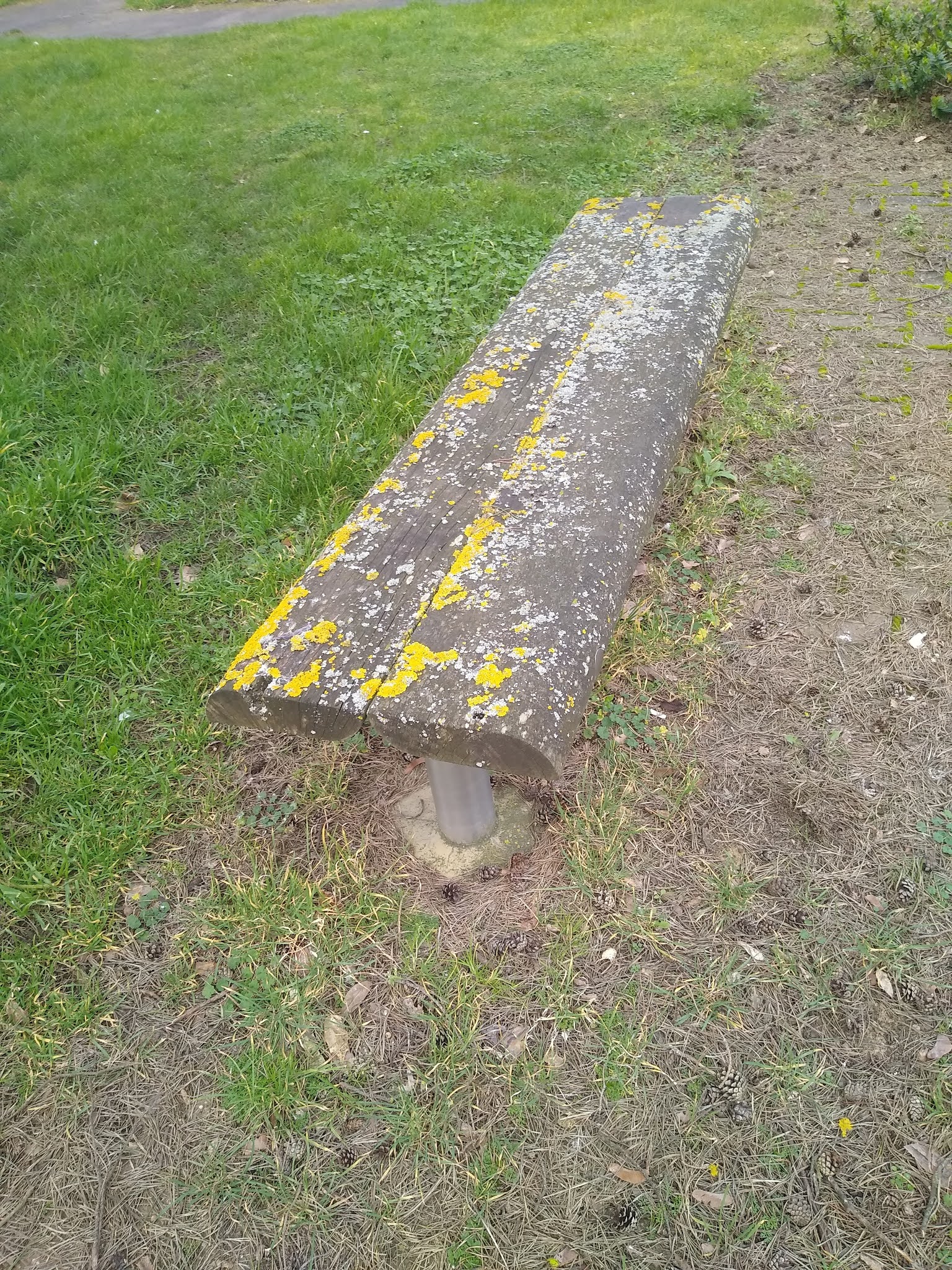
Just beyond, I found myself in a small open space between the houses that contained two concrete looking benches at opposite sides. They were colonised with glowing yellow lichen, and on closer inspection, I discovered, were actually wooden rather than concrete. The small estate seemed deserted and was silent. I detected no sounds emanating from the small houses that surrounded me. The benches resembled artifacts frozen in time, as if colonised by the lichen after a period of prolonged disuse, following some sort of low-key cataclysm. Another large green area was just across the way, breaking up the buildings. It offered no passage beyond to anywhere else and existed seemingly because it was necessary for its own sake and to offer an uneven but benevolent grass respite for the residents of the estate.
The path took me in the opposite direction, and to an area of three storey flats that I had no idea existed here. These gave way to Maitland Avenue, one of two streets that ran North. These were lined with the familiar type of brown post war municipal housing. Emerging from the end of the street, I took a left turn to investigate a passage that was shown on the 1980 map as leading to the Nuffield Road Industrial Estate. The passage was still there, just beyond the border of the map square. The entrance was marked by three posts. The stumpy concrete one was flanked by two taller and metal accomplices. An ambassador of Terminus, it marked the border between the residential and industrial and also (roughly) the boundary of the grid square. There was no question of passing beyond this concrete sentry. I almost unconsciously turned back to continue my exploration of the grid square that I had been allocated, as if gently but firmly encouraged to do so by the aging concrete post.

I soon found myself back on Green End Road, the main route out of Chesterton at this end of the suburb. I crossed over in search of the rec shown on the map, apparently located somewhere behind the houses on the other side of the road. A couple of large posts caught my eye and drew me towards them. Closer, I found they marked the entrance to a roadway between two houses. They looked like they ought to be supporting a huge gate, but instead there was an insubstantial and open metal barrier on each side. At the top of each post was a screen-like square, which I supposed might house a CCTV camera or some other security monitoring device. A sign indicated that the Browns Field Community Centre lie ahead. Looking at the map, the site of the rec ought to be somewhere in the same direction, so I passed between the posts to see what was beyond.

Behind the houses the space opened up into a small liminal zone. A place of uneven asphalt with scrubby grass at the edges, it was home to a skip, a possibly abandoned car trailer and an unceremoniously dumped shopping trolly. The latter was in a space behind some semi-aged concrete posts, as if being either protected or imprisoned by them.

I paused in the space for a moment. There was no sight or sound of anyone, although I stood behind several houses and their back gardens. Though the asphalt and brick-like path to one side of it were clearly relatively recent additions, I felt like I was standing in a zone that had been undisturbed for some time and one rarely visited. As I looked back, the main focus in the open space was the skip, which seemed to mark disposal of whatever had gone before and the interval preceding what was to come. At the beginning of the end of the Covid era, I wasn’t certain whether to take this as an optimistic sign that improvement was on the horizon. Or, if instead, it signified something more ambiguous about the disposal not just of lockdowns and restrictions, but many of the things previously taken for granted in the ‘old normal’ pre Covid and pre-Brexit era.

I left the ambiguous space and crossed onto a path that ran alongside the community centre on one side and a sloping greenspace on the other. A mother and toddler son occupied a bench at the edge of the space, so I didn’t feel comfortable invading their space to wander into the greenspace to explore. I stuck to the path and carried on through the zone that must have been the space previously occupied on the 1980 map.
‘A History of Browns Field Site by Derek Stubbings’ reveals that the space I found myself in had previously been part of the much larger Browns Field. This was one of several fields that surrounded Green end Road until the area was developed in the 1920s and 1930s. It was named after the owners, the family Brown, and was also known as ‘the pit’. The family presumably benefitted when the site was dug up to extract sand and gravel. After that, it was left to grow over, and eventually was surrounded by houses. In the intervening period before the Community Centre was built in 2005, it was used unofficially by children as a playground. I imagined a place resembling the Spinney in Cherry Hinton or the area beyond the Scouts Field I had visited in Harpenden. The sort of unofficial space where nature was left to its own devices, unmanaged by The Wildlife Trust or Natural England. A place where nettles and brambles were allowed to thrive, providing an attractive environment for discarded mopeds, hedgerow porn and other detritus left by casual fly-tippers. A public information film warning area, much more attractive to kids than any official rec or nature reserve, if less so to dog walkers, nature enthusiasts and anxious parents. Derek Brown makes no reference to an official rec. I wondered if the area ever actually became ‘official’, with slides and roundabouts replacing the wilderness. Or perhaps the ‘unofficial’ use was recognised by the cartographer alone, who had decided to give the space some ‘official’ recognition when preparing the map in an attempt to retain it as a space for kids to play on in the future.
Next to the community centre was Browns Filed ‘Pump Track’. It resembled a BMX track concentrated into a small space. Pump tracks by contrast are apparently used by ‘pumping’- generating momentum by body movement rather than peddling or pushing the bike. This brought back dim memories of the Sandy Banks BMX Track which used to be located the other side of Chesterton near the river. Sandy Banks was at least semi-unofficial, some of the kids who used it claiming to have built it themselves on the apparently abandoned land. Another potential public information film nightmare that it is hard to imagine being allowed to happen now.
The path turned into yet another passage soon after the pump track and I left the remains of Browns Field behind.

Emerging into a street I could see behind the houses a green topped tower rising above in the near distance. I had noticed this before on various bike rides but never seen it up close. I was drawn towards it but there was no obvious throughway ahead. I was forced to follow the road.

I lost sight of it for a minute of two before it re-emerged, slightly larger but still inaccessible.

The street deposited me onto Scotland Road, which Green end Road morphs into somewhere around the rec near Cam Causeway. Here I was distracted by a small route the other side of the road. It led me to a car park behind some flats. A pair of signs, close to each other but both exactly the same, were keen to discourage fly-tipping near the bins.

While successful at keeping the immediate space in front of them clear, in the adjacent area just to the right a small gathering of detritus, including a mattress and a group of traffic cones, appeared to mock the pair of signs and their attempt at authority.

I doubled back and headed along Scotland road to resume my quest for the tower. It came into view sporadically as I searched for the next turning towards it. Eventually, I arrived at the turning into Ashfield Road, which was marked by another green topped church building. This one was low key in comparison to the tower, but still stood out as a landmark. The bizarre octagonal design and striking pale green roof made the structure resemble something that hand landed or been beamed down rather than built. Only the beige brick and white UPVC window frames and panels betrayed its earthly origins.

I followed Ashfield road, presumably built upon yet another one of the old fields of Chesterton. It was lined with brown municipal type housing found in many of these streets. The generously sized front gardens provided a varied display of use. My favourite one featured a slightly bumpy and not overly manicured lawn peppered with purple crocus flowers. The least impressive were the gardens mainly converted into gravel drives for the parking of one or more cars. This street, and most of the others in the grid square were made up of similar municipal housing (or in many cases former municipal housing). Through a contemporary lens it seems almost unimaginable that dwellings of this type could ever be built here, or indeed anywhere, for the benefit of ordinary people for council rents. The generous front and back gardens, as well as inner proportions of these dwellings, make more recently built houses look laughable. I imagined what the area would be like had the fields of Chesterton been acquired only recently by developers of contemporary homes. The walk would have been very different and probably crocus free. I tried not to think about it, and instead enjoyed the pre-right-to-buy atmosphere that permeated from the houses and gardens. No doubt many of the houses were now private and had been for years. But the bricks and mortar spoke of an earlier era of municipality, one that predated the current epoch of encouraging house price and home ownership obsessiveness above all else.
I reached a crossroads. In one direction was Eastfields, another field street! The other way was a cul-de-sac which, although featured on the 1980 map, contained much more recent looking housing and little else. Straight ahead was a short pedestrian and cycle path that led into Warren Road. I was welcomed to this portal by another discarded shopping trolley, this time with some passengers on board. A water butt and the remains of a bicycle were yet more ambassadors of Terminus, marking the border between zones.

I left behind the ghosts of municipality as I stepped into Warren Road, a street lined with 1930s semis, grass verges and trees. The trees were wearing colourful woollen bands, having been the beneficiaries of a yarn bombing. This seemed in keeping with the atmosphere which had changed to one of 1970s sit-com housing ubiquity and homogeneity, as a certain type of tranquil but uneventful Sunday afternoon suburban anywhere-ness pervaded.

Not far along, a passage turned off to the left. The decision to turn into it was almost involuntary. Chesterton seemed to be blessed with a healthy number of back passages and short cuts for the pedestrian. This one followed the length of back gardens from Warren Street and the parallel Chesterfield Road. At the entrance stood another shopping trolley and half way down between back gardens an electricity substation, behind a wooden gate marked with the familiar ‘danger of death’ symbol. I encountered no one but could hear voices from one of the back gardens beyond the just audible hum of the substation. The space was a hybrid of the liminal and the suburban.

I emerged into Chesterfield Road which was almost indistinguishable from Warren Road. That is until I reached St Georges Church, the source of the green-topped tower I had seen earlier. The building was of a similar vintage to the houses that surrounded it. The tower was as impressive close up as it was from a distance. The distinctive pale green top was a beacon that marked a spot just off the centre of the grid square. A focal point of G7 and a surveyor of everything within the square’s border.

Near the bottom of the tower, a statue of St George stood upon a plinth within an alcove, the slain dragons head at his feet. The medieval image was in stark contrast with the 1930s built church and its surroundings, which included a flat roofed church hall that in part resembled a 1960s school science block. Thankfully there was no sign of the sort of right-wing nationalism that has sought to claim St George as its own symbol over recent years. The statue remained silent and enigmatic, facing West but with eyes closed. I considered if this might be an avatar of Terminus, marking the spot at the epicentre of Grid Square G7.

After a brief loiter at the base of the tower, I left the scene, passing a modernist house with a green tiled roof and a flat roofed extension with Crittall windows. Around the corner, between this and the more run-of-the-mill semi next door, the tower once more made an appearance, the statue facing me directly as if sending me on my way.

I continued along the rest of Fraser Road to emerge onto Milton Road. I decided to head East to junction with Green End Road and Kings Hedges Road. This marked a point along the northern border of the grid square, which cut across the top of the junction. I felt the walk would be incomplete without a visit to this landmark and boundary. In in 1980, according to the map, the junction had been a roundabout rather than the current traffic light system. I stood at the barrier that separated the road and the pedestrian asphalt in front of the Co-op and looked across to the map border. Just beyond it stood the Golden Hind, a 1930s Tolly Folly. The impressive, almost castle like brown building features a clock tower with a pale green spire, emerging from behind the rooves and chimney stacks. A boozy relation to the church spire of St Georges, marking closing and opening times. The pub has a large car park and dates from the age of the ‘roadhouse’, when large pubs on arterial roads away from main city centres became popular destinations as car use became more popular. This was a time when the dangers of drinking and driving hadn’t been fully thought through. The Tolly Brewery in Ipswich built several similar pubs, mainly in Ipswich itself. One of the Ipswich follies is also named the Golden Hind, a place I had encountered on my Ipswich Town Map walk. Thus, the landmark I was looking at was not only a significant border marker in relation to the grid square. It was also a portal back in time space, linking to Ipswich and its namesake folly there, the period of their construction in the 1930s and to my excursion using the Ipswich map, part of the same series as the Cambridge 1980 map I was using now.


After a brief pause, I followed the only other exit from the rec. The narrow passage pointing East cut between two back gardens, one with a precariously leaning fence. I had to lean too in order to pass.

East was the direction I wanted to go in, to get to the former green area on the map and see if any traces of the anthrax burial ground still existed. But the road took me North briefly until a passage provided the first opportunity of escape from Ramsden Square. A small grey post stood at the entrance, a discarded empty fizzy drink can at its base. Another border guardian.

I was deposited into Campkin Road, at the bottom end of the Kings Hedges Estate, a vast (for Cambridge) amalgam of houses and flats mostly built at various stages between the 1960s and 1980s. I headed East, realising that I had just breached the border of G7, but that the way back South of the gridline was not far away, down a shared cycle and footpath that lay between some flats and an old people’s home.
This route took me to Woodhead Drive, a street that horizontally bisected the housing estate now covering the green area on the map. Directly opposite was a building that initially looked like a large bungalow or small old people’s home but on closer inspection was clearly neither of these things. There were large steel devices fixed to the walls that looked like extractor fans put on the wrong way around and red windowless doors that looked impossible to open. A low-level hum emanated from the building and the space around the back was blocked off by metal gates. After a few moments of bafflement, I spotted s sign for BT Openreach, and realised it was one of their (possibly unstaffed) outposts.

I headed East into the housing estate that was made up of typically Barratt-style housing, probably dating from the 1990s. This featured a confusing array of pointless cul-de-sac dead ends and a physical dividing barrier between at least two parts of the estate, meaning that the only way to cross was via Woodhead Drive. There was no way out onto Milton Road and no sign of the athletics track that I assumed had been swallowed up by the estate. A look at the current OS map seemed to confirm this. I headed back to the BT Openreach building, at the same time underwhelmed and confused by the estate. On the way back I encountered two comparatively large green spaces, one behind some houses/flats and one making up a green ‘square’ buffering some of the houses from Woodhead Drive. Both these green spaces were minor hillocks, resembling burial mounds and unusually uneven. It seemed odd that the developers would not have wanted to cram more houses in rather than allow such an expanse of green space. I wondered if these were sites where anthrax infested horses and cattle had been buried prior to the development. But more likely the planning permission decreed some green space. This was a few years ago after all. I surmised that the uneven surfaces were probably accounted for by the burial of unwanted plant and building materials by the developers, a sort of construction industry unmarked grave being the cheapest option for disposal.

Later internet ‘research’ produced a few clues to the former anthrax site. Minutes of a Cambridge City Council Development Control Forum in 2003, concerning development of George Nuttall Close, off Woodhead Drive, mention that the ‘issues of the risk of exposure to anthrax and radioactivity had been thoroughly researched and dealt with’. It went on to confirm that ‘the University would own the land where the anthrax infected carcasses were thought to have been buried’ (my emphasis) and that ‘there was no radiation above background levels’. The specific site subject to the planning application was that of the former ‘Dunn Nutritional Unit’ buildings, a name that immediately brings to mind the sort of remote ramshackle light industrial complex often found in episodes of Dr Who and The Avengers and where secret Government activity was taking place.
One commentator on a Google Group from 1999 confirms that there were collaborative University and Government Biology Research labs on the site where the housing estate now stands. Anthrax experiments were carried out either just prior to or during World War Two, when the site was farmland and would have seemed much more remote and isolated than it is now. The research lab was housed in one of many ‘tatty sheds’ dotted about, in line with the bizarre lo-fi image the name ‘Dunn Nutritional Unit’ conjured up. Later apparently Acorn, the people who brought us the Electron and BBC B home computers, had a shed on the site at a time when the Cambridge Tech boom was in its early stages. Ramshackle sites like this were no doubt precursors of the Science Parks that arrived a few years down the line. The site, pre development, was known locally as ‘the Anthrax Site’ and around 1980 (time of the map!) a local football team called themselves Anthrax Rovers. By then the anthrax experiments had become more legend than fact. Google commentator mentions rumours of the burials being somewhere between Milton and Huntingdon Roads, a vast area, and possibly at the Frenches Road Mill, off Histon Road, a place now converted into business units. I haven’t been able to find any reliable information on the exact spot of the burials (if indeed there were any) and they remain a possibly intentionally obscured part of the mythology of 20th Century Cambridge.
Back on Milton Road, I soon arrived in front of the Milton Arms. This is another large pub, consistent of the type found on arterial roads, if not quite Tolly Folly league. I paused an looked up at the pub sign. Within a sphere, a depiction of St George, presumably a nod to the church at the epicentre of G7, was being loomed over by the face of an otter. I have yet to make sense of this combination of imagery.

Next to the Milton Arms, still there as shown on the map, is a cul-de-sac known as John Clarke Court, Clinical looking white signage marked the entrance, with a website and website address for something called Anchor. At first, I mistook this as belonging to a construction business and expected to see some sort of development going on. But as I passed into the cul-de-sac, which opened out behind the Milton Arms’ car park, the low-rise single storey buildings I encountered were obviously retirement flats.

A concrete plaque on the wall of one of these buildings,
that faced the resident’s car park, revealed that the buildings were erected by
the East Anglia Licenced Victuallers National Homes. Edinburgh Estate may have
referred to the buildings themselves, though ‘estate’ would be a bit of an out
of proportion term for the modest size and number of dwellings. Maybe it was referred
to the cluster of roads around Edinburgh Roads over the way in Chesterton, but
there was no obvious connection. I haven’t been able to trace the real meaning
of this, although have discovered that John Clarke was managing director at
Greene King. The Milton Arms is still owned by Greene King, the East Anglia
Regional Brewery that has outlasted and ultimately bought out, its main rival,
Tolly Cobbold. The brewery is now known as much for its property portfolio than
its beer or the enigmatic figure of the Greene King, who used to be a
ubiquitous feature in and around the pubs. Most strikingly, usually permanently
embossed into the brickwork of the exterior wall of the pub next to the doorway, as an irremovable enigmatic welcoming icon. But in the case of the Milton Arms, seemingly ursurped by an Otter and St George.
Victuallers are those licenced to sell alcohol and the dwellings were originally built for retired ones- ex pub landlords. Despite not being averse to a visit to the pub, I’d never heard of the term ‘victualler’, nor had I known about their National Homes or John Clark. While I stood on the site, I was not much wiser, only finding this out when I got back. The thing that struck me at the time was the date. The buildings were officially opened in 1980. The concrete plaque represented yet another border, a portal lack to the time of the map.

I began to head back to Chesterton, sensing it was time to draw the walk to a close. I passed a small new development called Sorbus Walk, which was too new and glassy to have blended in very well with the 1930s ribbon development along Milton Road. But in time no doubt would fade into its surroundings. At the time I misread the sign as 'Scorbus Walk'. I supposed that housebuilders have to become ever more imaginative with names, but using the name for a friendship (or possibly implied homosexual relationship) between two characters from Harry Potter seemed an unusual choice. I couldn't think of a local connection, other than the University often being likened to Hogwarts. When looking back at the photo later I realised my mistake, 'Sorbus' is the genus of plant that includes 'Sorbus 'Domestica' or the 'Service Tree', which looks like the type of plant that might be planted on contemporary housing estate featuring large red or orange berries. That made more sense.

Back on Warren Road, I passed the shopping trolley/water-butt/bike ensemble again and turned into Eastfields. I followed the road, the houses to my left possibly still obscuring the allotments shown on the map. I couldn’t tell if they were still there and found no track leading to them. Past some three storey flats, I followed the road as it curved back towards Scotland Road, passing through the other Scottish Streets. I was looking for a passage that appeared to be there on the map linking through to Union Lane. There was no sign of this. I wondered if its disappearance was symbolic of increased appetite in Scotland to leave the Union, and the ‘Scottish streets of Chesterton had severed their ties already. Subsequent google search show allotment entrance exists via Union Lane but that would have meant going all the way around and across the border of the map square.
Soon I was deposited back onto Scotland Road and crossed
over and headed down the final passage of the day, called Martin’s Stile Lane. Whether Martin was an
owner of a Stile and who he was remains enigmatic. But the lane brought me onto
High Street in old Chesterton, just over the border of Grid Square G7 briefly
before I stood on the grid square border Primary Court, a small housing
development where a school had stood at the time of the map.

Soon after, I left the high street for Water Lane and back to the confluence of roads where I started. The bollards that stood here represented the final border standing at the boundary of the map square. I passed through them and out of the realm of borders, landmarks and passages that made up G7 then crossed the Green Dragon Bridge and headed home.

No comments:
Post a Comment