I met R at the top of Castle Mound, the agreed starting point for a Sunday afternoon random perambulation.
On the way, I had passed Heavy Metal Bike Man near Christ's Pieces and Disco Kenny in the car park next to Castle Mound. Bike Man was parked up in a side street across the road, partially obscured from the view of the pedestrians crossing between the Grafton and the Pieces. I'd never seen him static before. I guessed he was summoning the energy for his ride. Preparing to keep the demons out of the city, using the power of tinny distorted heavy metal blasted from a plastic bag on his handlebars. I wondered if he took a pre-ordained route, one which mapped out an occult pattern connecting sites of important psychogeographic significance. Meanwhile, Disco Kenny was, as usual, kinetic and not static. He was moving across the car park at pace, coming from the North of the city and heading towards the centre. Presumably towards the first pub and half pint, the first of several for the afternoon, where he would tell people that 'the world's gone mad'. His movements were as ritualistic and repetitive as Bike Man's, if perhaps more random. I wondered if their paths ever crossed, or if anyone had ever mapped their movements.
Encountering both of these figures on the same day, let alone within ten minutes of each other, was unusual and seemed significant. Maybe it was symbolic of a re-emergence of some sort of normality. Town was busy. It felt like the shadow of Covid had begun to retreat, but was leaving things not quite as it had found them. I was reassured by the presence of these two familiar characters. It felt like they were maintaining a sort of equilibrium during uncertain times. Disco Kenny and Bike Man are the most significant of a much dwindled cast of these types of local figures. When they have finally departed the world will have truly gone mad.

The mound itself is a significant site. It was identified by the London Psychogeographic Association (LPA) as an 'important place to cleanse the malevolent influence of the University which pervades the town of Cambridge'. The LPA linked the mound (or mount as they called it) to other similar structures in Lewes, Oxford and elsewhere, noting that all had largely been left undisturbed in the hands of municipal councils. That was in 1993. The mound is on the site of the Shire Hall (picture above as seen from the mound), the HQ of Cambridgeshire County Council. But not for much longer. The wheels are in motion for the Council to vacate the premises and lease them for use as a hotel. There have been concerns that the public right of way to the mound will be lost, despite reassurances from the Council that the new leaseholder will continue to allow public access to the ancient site. How that pans out remains to be seen. It seems that 'efficiency savings' are forcing the County Council headquarters to relocate to the far flung Alconbury Weald, off the A1, North of Huntingdon. Thirty years on from the LPA's 'The Ascent of Cambridge Mount Souvenir Programme', it seems that rather than the University, it is the ever ongoing expansion of 'private-public' spaces, as land and buildings are increasingly abandoned by municipal authorities and passed into the hands of private profiteers, that is the main malevolent influence these days.
I had brought the Cambridge Map and dice to use as a catapult. We spread the map open on peak of the mound. The square chosen by the dice was F5, at the centre of the map. It included Christ's Pieces, most of what is left of The Kite and Parkers Pieces, all significant spaces in their own right. It also included grounds of three colleges, Christ's, Jesus and Emmanuel, rendering a fair portion of the square inaccessible.
We headed to Christ's Pieces and to the Diana Memorial Garden, at its centre. There were more people around than we had bargained for. All seats in the Diana Memorial Garden, which is a small circular arrangement of four benches, some metal arches and some flowerbeds, were full. Instead, we headed to one of the three alfresco ping pong tables. One was not being used and we spread the map over it. We decided to head to the perimeter of the square and circumnavigate the border. I photographed the square with my phone for easy reference.
Christ's Pieces is significant perhaps for being the most central open green area for use by the public, in a City where the bulk of central green areas are behind college walls. Most use it to move between the town and the Grafton Centre. But there is a bowling green and tennis courts and its well used for sitting about on. Its a point at which Town rubs up perhaps most closely with Gown, if only in physical proximity. The other side of the wall on the Easterly side is Christ's College grounds. Emmanuel College is just over the road from the bus station, hidden behind its own walls. The recently reopened Christ's Lane, that runs along part of the border with Christ's College, linking to the town centre, contains a disappointing selection of retail outlets. These have replaced Bradwell's Court, a 60s shopping precinct, that no doubt at the time of its building was much maligned. But what has replaced it is certainly no better and of less interest. Christ's Lane, heading away from Town, turns into Miltons' Walk, named after the poet John Milton who was a student at Christ's College. The walk links the rather dull chain stores at the Christ's Lane end with, by stark contrast, the excellent Champion of The Thames pub at the other. At the other end of the bus station from Christ's Lane, opposite Emmanuel College, there is the bowling green and some of Cambridge's least salubrious public toilets.
R and I noticed a lack of young people drinking Thunderbird and cheap cider, which was probably the activity we most associated Christ's Pieces with from our youth. During that era, I once saw Roland Gift from the Fine Young Cannibals meditating under a tree here. He was stoically ignoring the approach of a man we only knew as 'How Do You Feel?', a tramp of the proper tradition. He had a wild beard, a knackered old jacket and had Bob Dylan lyrics as, apparently, his only means of communication. There were none of his kind here today. They seemed to have disappeared at some point in the late 1990s, before which they were ubiquitous users of the Pieces.
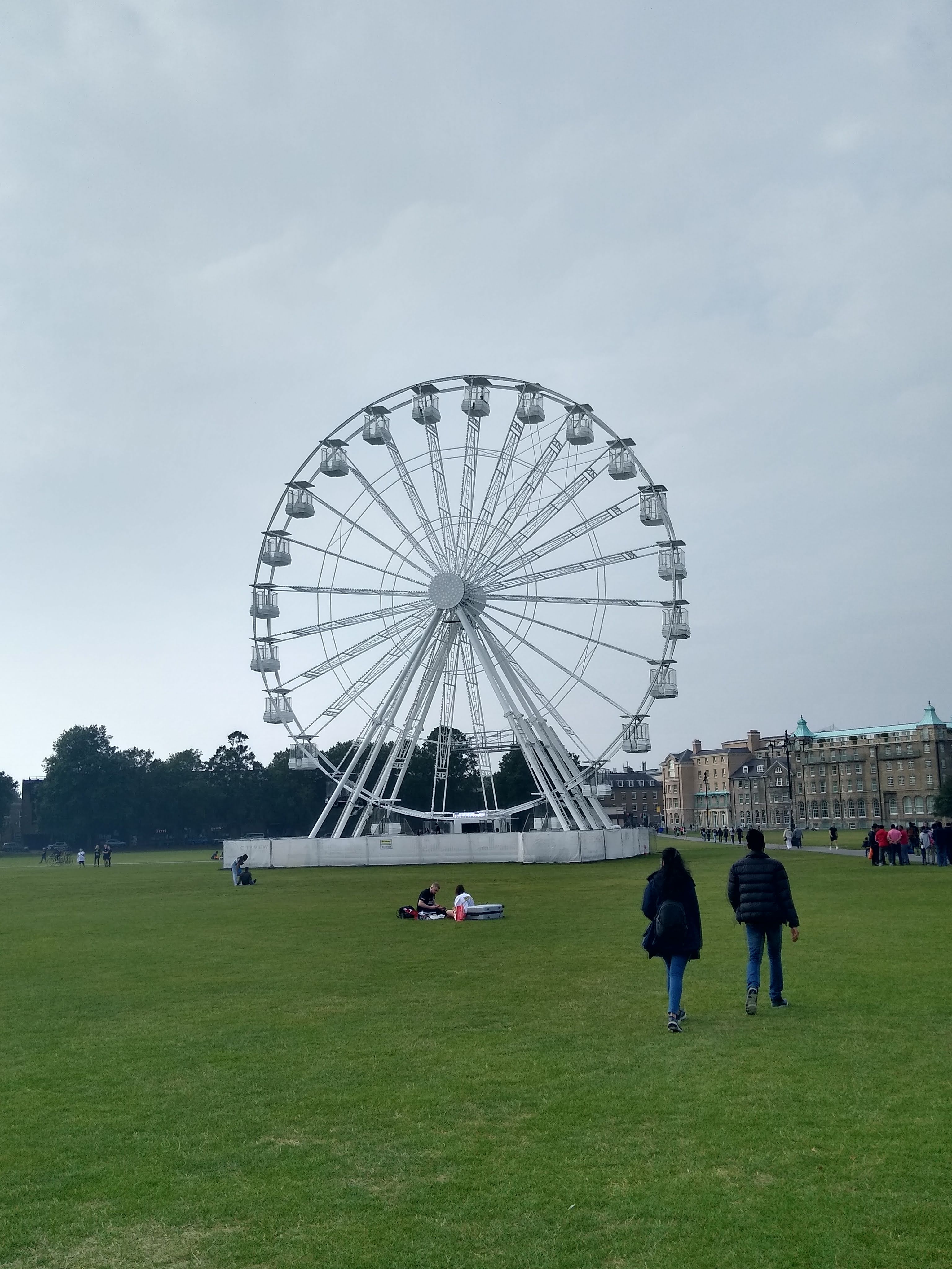
The amount of people of Christ's Pieces was off-putting, with the spectre of Covid almost unconsciously making us avoid anywhere crowded. We headed across to Parkers Piece, a wider expanse of green space. Parkers Piece currently has a ferris wheel located at its centre. A sort of lesser version of the London Eye. We were intrigued enough to give it a go. Not intrigued enough to ask what extras were included with the one first class 'carriage' which was distinguished by being painted black rather than white. The experience was slightly unnerving at first It felt much higher at the top than it looked from below. At the top, the wheel stopped for a few minutes. Instead of taking in the panorama, I was distracted by the sight of some orange robed figures below, possibly Hari Krishna people which are quite a rare sight these days. I haven't been hawked one of their publications for some years.

The wheel went around three times, which was unexpected, but on the other hand one rotation didn't allow enough time to take in the panorama. Being local, most of the views were of no surprise. But I spotted two large square white roofed buildings, still apparently under construction and surrounded by cranes. They appeared to be somewhere between Mill Road and Marshalls Airport. I still haven't managed to figure out exactly where or what they are.

Back on the ground at nearby Reality Checkpoint we considered our next move. Reality Checkpoint is a four lamped post at the central point, where the two paths that cross the Piece meet. It is a well known local landmark and significant in the psychogeography of Cambridge. It is said to signify the point where Town meets Gown. For Cambridge University students it marks a transition from the University/College to Mill Road, a place much more accociated with 'Town' and a marked shift away from the 'Gown' University environment. Another persistent rumour is that the post has always provided a useful marker for drunk or stoned people who could recognise the lights as they crossed the Piece and so be roused from whatever otherworldly state they were in. In those circumstances, no doubt it serves as a useful reminder that the Police station is just across the road and to act straight.
'Reality Checkpoint' was scratched or painted on the post persistently for years. Yet more rumours have it that students and possibly staff from Cambridge College of Arts and Technology (CCAT), on nearby East Road ('town' side), were responsible for the upkeep of this. Each time the Council painted over it they reinstated 'Reality Checkpoint'. These rumours are probably enhanced by the attendance of Syd Barrett at CCAT before he did Pink Floyd. The lights were apparently also a beacon during the 'pea 'souper' fogs of the 1950s. The name was finally made official and painted on permanently in 2017.
We found he post had been adorned with ribbons, which along with the staring red eyes of the fish, gave it a strange ritualistic air.
We headed away from Reality Checkpoint and the Wheel, which now, again, seemed much less significant in height then when we were up there.
To contrast the view from the wheel, we headed onto the roof of the Queen Anne multi-storey car park across the road. The view itself was much less impressive than we had hoped. It seemed to be impossible to get to the highest point where a profusion of mobile phone masts and other antennae were sited, on what looked like a small tower. We made do with the other side, where the stairwell door deposited us. The deserted scene looked frozen in time from the 1970s, if you ignored the few cars that were parked this high up. We saw no people, though there was evidence of skidding and fast
driving which seemed out of kilter with the limited space available. I
imagined dangerous late night car meets, or maybe moped meets took place here, along with associated clandestine activities.

Pedestrian access was limited, at least officially, to certain designated areas and the ramps between floors were off limits. The pedestrian depicted in the warning sign looked like a person from the era when the car park was built, judging by the slightly flared trousers and cuban heels. The person also looked to be adopting a strange hand gesture, as if the recipient of a 'back-hander'. This made me wonder about the origins of the car park. It was opened in 1971, after delays caused by lack of finance and because it went against the County Development Plan for the area. Obviously the lack of finance was somehow resolved and the planning issue somehow ceased to be a preventative factor. It still stands as one of few buildings in Cambridge that approach 60s/70s Newtown architecture, not quite brutalist but the nearest thing we have. The only other comparable buildings I can think of are other car parks, including Park Street ,which is of similar vintage and soon due for demolition to make way for a hotel.

We came back down a different stairwell and upon reaching the ground floor encountered a tea set, that had apparently been unpacked from a plastic bag and laid out on the floor. with some care. Rather it was a mixture of bits of different tea sets. The arrangement was odd but apparently deliberate. There was no sign of the people responsible and the purpose remained ambiguous. It looked like they may have been disturbed and left the scene in a hurry before anybody saw them, judging by the teapot on its side.
Gareth Rees described a plethora of unusual and normally unnoticed human activity in car parks in his book Car Park Life. But I don't recall him mentioning anything to to with clandestine tea and cake rituals in the stairwells.
Although I was quite taken with some of the plates, it seemed wrong to interfere with the crockery and we we left it undisturbed. Once we were the other side of the stairwell door, there was no readmission. The door was locked behind us and the scene preserved, at least until the next curious passer by came along down the apparently little used stairwell.
Back over the road on Parker's Piece, we stopped at the trio of monolithic concrete structures in the South Easterly corner. These memorialise the invention of the rules of Association Football, which were conceived by the University Football Club in 1848. These days the University is more associated with Rugby. Meanwhile, Cambridge's second football team Cambridge City are no longer even located within the City. They share a ground with Histon FC, just outside the city boundary on the other side of the A14. Their previous grounds near Mitchums Corner was sold off for development a few years ago. Cambridge United, meanwhile, continue to remain at the Abbey Stadium but there has been talk in the past of selling the grounds and moving further out of town. Cambridge United are currently in 'Sky Bet League One', which as far as I can work out translates into what used to be called the Third Division. Meanwhile, City play in something called Level Four of the Non-League Pyramid. So, while the rules of modern football may have been invented on Parker's piece, the City's association with football prowess in living memory is not notable. I doubt Cambridge even made the long list for Ian Nairn's 'football towns' series. However, the location of both grounds is significant for being on the 'town' side of 'Reality Checkpoint', while two of the three Rugby Grounds in Cambridge are located well within the vicinity of the University dominated area around Grange Road and Newnham.
R said he'd heard that originally the football rules memorial was originally going to be a giant Subutteo referee figure, sited where Reality Checkpoint is. The idea was been scrapped in favour of the more subtle trio of monoliths, which align with Reality Checkpoint if you stand behind them in the right place.


We drifted into The Kite and stopped at the Elm Tree for a pint. The Elm Tree is one of a trio if pubs situated close together and the one with the most interesting beer. It was quiet when we arrived and we took a bench outside. Gradually more customers appeared and the other benches became occupied. We hadn't been there long when a character known as 'Dead John' made an appearance. I think it was a former barman at the Elm Tree who I first heard refer to the aging black clad figure using that name. Dead John always appears in modern day 'goth' garb; large thick soled black boots, a bag with rubber spikes on and sometime a top hat and cane. I have never heard him speak or seen him smile. The Elm Tree seems to be a place he gravitates to. It is said he is an academic of some sort. Unlike Disco Kenny or Bike Man, he is a character from the Gown side of Reality Checkpoint. The Elm Tree exists in a sort of transitional interzone where both sides meet. Disco Kenny is certainly no stranger to the Elm Tree and the other pubs nearby.
After a nourishing pint of Brazilian Coffee Stout, we headed towards Mill Road, with the intention of taking the side entrance into Anglia Ruskin University (formerly CCAT). Near to this, at the end of Willis Road, is The Sinclair Building. This had been the HQ of Sinclair Research between 1982 and 1985, during the heyday of early home computers and the height of the popularity of the ZX Spectrum. Coincidentally, Clive Sinclair had died the week leading up to the walk and I had seen the building, with its original logo eblazened on its silver facade, featured on a regional news report that used archive footage. The report also had a man at the Cambridge Computer Museum demonstrating an old ZX Spectrum in action. He had the game Jetpac loaded onto the screen, one of hundreds of primitive computer games that are seared into the memory of a certain demographic.
Now Spectrum emulators are available online so that these pre-digital, originally tape loaded games can be re-lived. Like old music, films and other cultural artefacts that would otherwise have aged into obscurity, obsolescence and inaccessibility, the digital age has brought these games back from the dead, into a period where they are no longer the captive of a particular time or space nor belong to a particular generation. Sinclair was part of '
the Cambridge Phenomenon', a phrase coined in 1980 to describe the explosion of Tech companies in Cambridge that began in the 1950s. I recently found a publication in a charity shop of the same name, a report by some consultants produced in 1984. It is contemporary with Sinclair. The 'phenomen' has continued to explode and now Cambridge is home to offices of Microsoft, Amazon and Apple among many others in the tech field. ARM now occupy the site of the old Acorn building on the edge of Cambridge. Acorn was a comtemporary rival of Sinclair with its Acorn Electron and BBC B computers. The old games played on Spectrum and Acorn computers are still alive and well, embedded in the digital world far more advanced but that descends directly from the earlier technology those companies helped create.
The building behind the gates we stood next to still had the silver facade at one end, but the old Sinclair logo had gone. The building is now part of Anglia Ruskin University. An older looking sign still remains on a low wall outside.
We found the back gates of Anglia Ruskin locked. It turns out they are only open during the week, when the public are free to pass through. It serves as a useful and interesting shortcut to East Road, which is where we intended to head next. We had to take the alternative route through the graveyard that runs behind the campus instead.
The graveyard in recent years has become more popular for use not just as a cut through but almost as a park. During lockdown it became a place festooned by dog walkers, who could be seen chatting in the middle of a small green space on the site of the old chapel. Meanwhile, their dogs would run amok into the surrounding graves and bushes to chase balls thrown by their owners and occasionally would make unwelcome advances to other people who sat on benches hoping for some peace and tranquility before work. Previously, the graveyard had been noted for anti-social behaviour like drug taking, drinking and grave vandalism. Indeed, during lockdown for a short period, an apparently threatening character had been marking graves with satanic symbols and was aggressive towards anyone who challenged him. I never encountered this troubled character, and I suppose by comparison the odd irritating dog approach or stray turd is much easier to deal with.
We emerged onto Norfolk Street, opposite the small parade of shops. R and myself used to come here on Saturday mornings many years ago to eat breakfast at the Athena Restaurant. This was a particularly excellent Grease Cafe of the sort no longer seen in Cambridge. There are still places to get a fry up, but none are really proper greasy spoons. The premises are currently occupied by Eko Kitchen, an African Restaurant, which I still need to try. Previously, after the Athena, it was the Pandahar Indian Restaurant. So it was good to see that, though the Athena has been lost to the whims of history, the tradition of interesting and not overpriced food continues on its location.
The demise of the Grease Cafe in general has parallels with the decline of the proliferation of traditional wet led pubs. Both seem superficially to be the victims of a culture promoting healthier lifestyles. But since places like McDonalds and Kentucky Fried chicken, and sales of wine, beer, energy drinks and other junk food items at shops don't seem to have declined much, this can't be the sole cause. Property development and Whetherpoons are probably equally, if more, to blame.
I'd never really noticed the metal shutter across the street before. I couldn't recall what, if anything other than the metal, had been there before. The ubiquitous Nigel had got there before me, or possibly one of many Nigels. The tag is everywhere. I suspect behind it there is a grafitti/street art version of Luther Blisset, with a multiplicity of people using the tag and acting as a loose collective.
We left Norfolk Street, and crossed into Burleigh Street, past the old Boat Race pub, now a vegan eatery of some sort. Burleigh Street was busy with post Covid shoppers, emerging mainly from Primark. We avoided this by taking the route behind the shops, before re-emerging further up the street near the entrance of the Grafton Centre.
It was announced recently that the Grafton Centre had been sold. Its future looked uncertain. Before Covid it was struggling to fill shops, and saw the departure of British Home Stores. Covid made things worse and the loss of Debenhams was perhaps the final straw. While neither of us had ever had much of a fondness for the Grafton Centre, we thought a (possibly) final visit was in order. This was also influenced by the comparative lack of people inside as compared to outside on the street and the knowledge that it contained a toilet. The stout quaffed earlier was re-making its presence felt.
The atmosphere inside was lacklustre. The people wandering around inside looked even more bored and aimless than usual. The Grafton had been used as a Covid vaccination centre but that activity seemed to have ceased. Of the few shops opened, none enticed us inside other than a sort of Mediterranean deli/shop. Though some of its wares were tempting, there was nothing that could be consumed immediately and I couldn't really muster up much enthusiasm. I think in part, this was due to the 'indoor shop-ness' of it. In my mind there is still something not quite right in emerging out of a shop and still finding yourself indoors.
Some of the other 'units' that were not empty were being put to alternative uses. In the indoor ping-pong hall that had been here a while, the cow statues from the Cambridge Cow Trail had been herded inside. This was to allow viewing for their auctioning off. The Cow Trail had been a phenomena over the summer, consisting of a large number of identical cow sculptures that had each been customised by artists and schools. I had considered doing the trail in its entirety, but never quite felt like it, instead I had 'visited' the sites of some of the cows during random walks. The cows had been mostly confined to central Cambridge and the area around the Station, but a couple had been posted at Cambridge North Station.
We decided not to go in, due to the relatively high number of people. Instead we headed up to the balcony, where the entrance to the cinema and various eateries link to the stairs and the car park and some toilets. We checked out a couple of the food vans, the sort that normally park up as 'streetfood' offerings at events. Somehow these had been elevated up to the second floor. We were not enthused by their offerings or of those in the cafe below.
The view across towards the former British Home Stores (now H&M and a Gym), invoked feelings of emptiness and fatigue. Even though the Grafton was not my favourite place and I've never quite forgiven it for replacing the part of The Kite that I never really got to see, I did feel a bit sorry for it. I even had a flash of nostalgia for the days of fish smelling supermarket Prestos, the Reject Shop, Our Price and even the officious security men and their random tannoy announcements.
The scene we looked over now had once been a continuation of Fitzroy Street before it was bulldozed to make way for the Grafton Centre. It represented a lost future where there might have been a proper outdoor street lined with shops, grease cafes and pubs surrounded by reasonably priced terraced housing for rent or purchase. But more likely it would have ended up heading towards gentrification in the same way as Mill Road. Instead, the Grafton Centre and the pedestrianised Burleigh and Fitzroy Streets immediately outside, are places 'ordinary' people go to shop. Places firmly on the Town side of Reality Checkpoint, physically and metaphorically, as they would have been before the Grafton was built, back to when the Kite was part of Barnwell. So paradoxically, the bland Grafton Centre has in some ways been a force against gentrification, if nothing else. But with its sale and the mystery of what it might become, maybe that will all change.
The lacklustre atmosphere of the Grafton had permeated us. We walked a bit further to Jesus Green. Somewhere here border of F5 crossed the Green but we had lost our concentration and overshot. Somewhere around Jesus Green Lido, well outside outside square F5, we called it a day.


