Showing posts with label Grease Cafe. Show all posts

Thursday, 30 September 2021

The Cambridge Map Project Episode 4: F5, Reality Checkpoint

I met R at the top of Castle Mound, the agreed starting point for a Sunday afternoon random perambulation. 

On the way, I had passed Heavy Metal Bike Man near Christ's Pieces and Disco Kenny in the car park next to Castle Mound. Bike Man was parked up in a side street across the road, partially obscured from the view of the pedestrians crossing between the Grafton and the Pieces. I'd never seen him static before. I guessed he was summoning the energy for his ride. Preparing to keep the demons out of the city, using the power of tinny distorted heavy metal blasted from a plastic bag on his handlebars. I wondered if he took a pre-ordained route, one which mapped out an occult pattern connecting sites of important psychogeographic significance. Meanwhile, Disco Kenny was, as usual, kinetic and not static. He was moving across the car park at pace, coming from the North of the city and heading towards the centre. Presumably towards the first pub and  half pint, the first of several for the afternoon, where he would tell people that 'the world's gone mad'. His movements were as ritualistic and repetitive as Bike Man's, if perhaps more random.  I wondered if their paths ever crossed, or if anyone had ever mapped their movements.

Encountering both of these figures on the same day, let alone within ten minutes of each other, was unusual and seemed significant. Maybe it was symbolic of a re-emergence of some sort of normality. Town was busy. It felt like the shadow of Covid had begun to retreat, but was leaving things not quite as it had found them. I was reassured by the presence of these two familiar characters. It felt like they were maintaining a sort of equilibrium during uncertain times. Disco Kenny and Bike Man are the most significant of a much dwindled cast of these types of local figures. When they have finally departed the world will have truly gone mad. 

Shire Hall, Cambridge, Castle Hill

The mound itself is a significant site. It was identified by the London Psychogeographic Association (LPA) as an 'important place to cleanse the malevolent influence of the University which pervades the town of Cambridge'. The LPA linked the mound (or mount as they called it) to other similar structures in Lewes, Oxford and elsewhere, noting that all had largely been left undisturbed in the hands of municipal councils. That was in 1993. The mound is on the site of the Shire Hall (picture above as seen from the mound), the HQ of Cambridgeshire County Council. But not for much longer. The wheels are in motion for the Council to vacate the premises and lease them for use as a hotel. There have been concerns that the public right of way to the mound will be lost, despite reassurances from the Council that the new leaseholder will continue to allow public access to the ancient site. How that pans out remains to be seen. It seems that  'efficiency savings' are forcing the County Council headquarters to relocate to the far flung Alconbury Weald, off the A1, North of Huntingdon. Thirty years on from the LPA's 'The Ascent of Cambridge Mount Souvenir Programme', it seems that rather than the University, it is the ever ongoing expansion of 'private-public' spaces, as land and buildings are increasingly abandoned by municipal authorities and passed into the hands of private profiteers, that is the main malevolent influence these days.

I had brought the Cambridge Map and dice to use as a catapult. We spread the map open on peak of the mound. The square chosen by the dice was F5, at the centre of the map.  It included Christ's Pieces, most of what is left of The Kite and Parkers Pieces, all significant spaces in their own right. It also included grounds of three colleges, Christ's, Jesus and Emmanuel, rendering a fair portion of the square inaccessible.

Cambridge, Psychogeography, Castle Mound

We headed to Christ's Pieces and to the Diana Memorial Garden, at its centre. There were more people around than we had bargained for. All seats in the Diana Memorial Garden, which is a small circular arrangement of four benches, some metal arches and some flowerbeds, were full. Instead, we headed to one of the three alfresco ping pong tables. One was not being used and we spread the map over it. We decided to head to the perimeter of the square and circumnavigate the border. I photographed the square with my phone for easy reference. 

Christ's Pieces is significant perhaps for being the most central open green area for use by the public, in a City where the bulk of central green areas are behind college walls. Most use it to move between the town and the Grafton Centre. But there is a bowling green and tennis courts and its well used for sitting about on. Its a point at which Town rubs up perhaps most closely with Gown, if only in physical proximity. The other side of the wall on the Easterly side is Christ's College grounds. Emmanuel College is just over the road from the bus station, hidden behind its own walls.  The recently reopened Christ's Lane, that runs along part of the border with Christ's College, linking to the town centre, contains a disappointing selection of retail outlets. These have replaced Bradwell's Court, a 60s shopping precinct, that no doubt at the time of its building was much maligned. But what has replaced it is certainly no better and of  less interest.  Christ's Lane, heading away from Town, turns into Miltons' Walk, named after the poet John Milton who was a student at Christ's College. The walk links the rather dull chain stores at the Christ's Lane end with, by stark contrast, the excellent  Champion of The Thames pub at the other. At the other end of the bus station from Christ's Lane, opposite Emmanuel College, there is the bowling green and some of Cambridge's least salubrious public toilets.

R and I noticed a lack of young people drinking Thunderbird and cheap cider, which was probably the activity we most associated Christ's Pieces with from our youth. During that era, I once saw Roland Gift from the Fine Young Cannibals meditating under a tree here. He was stoically ignoring the approach of a man we only knew as 'How Do You Feel?', a tramp of the proper tradition. He had a wild beard, a knackered old jacket and had Bob Dylan lyrics as, apparently, his only means of communication. There were none of his kind here today. They seemed to have disappeared at some point in the late 1990s, before which they were ubiquitous users of the Pieces.

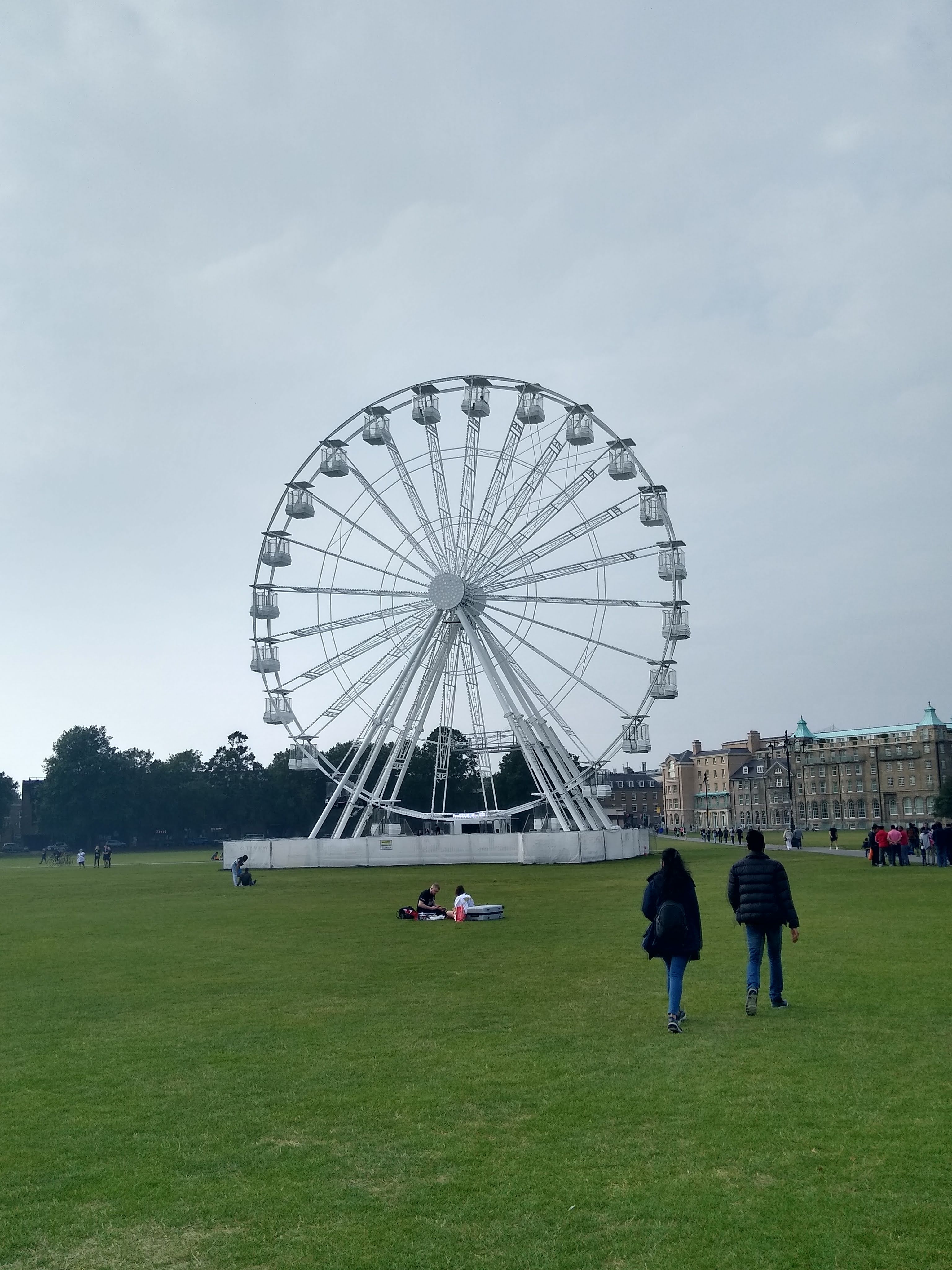
The amount of people of Christ's Pieces was off-putting, with the spectre of Covid almost unconsciously making us avoid anywhere crowded. We headed across to Parkers Piece, a wider expanse of green space. Parkers Piece currently has a ferris wheel located at its centre. A sort of lesser version of the London Eye. We were intrigued enough to give it a go. Not intrigued enough to ask what extras were included with the one first class 'carriage' which was distinguished by being painted black rather than white. The experience was slightly unnerving at first  It felt much higher at the top than it looked from below. At the top, the wheel stopped for a few minutes. Instead of taking in the panorama, I was distracted by the sight of some orange robed figures below, possibly Hari Krishna people which are quite a rare sight these days. I haven't been hawked one of their publications for some years.

Psychogeography, Cambridge, Parkers Piece

The wheel went around three times, which was unexpected, but on the other hand one rotation didn't allow enough time to take in the panorama. Being local, most of the views were of no surprise. But I spotted two large square white roofed buildings, still apparently under construction and surrounded by cranes. They appeared to be somewhere between Mill Road and Marshalls Airport. I still haven't managed to figure out exactly where or what they are.

Reality Checkpoint, Cambridge, Psychogeography

Back on the ground at nearby Reality Checkpoint we considered our next move. Reality Checkpoint is a four lamped post at the central point, where the two paths that cross the Piece meet. It is a well known local landmark and significant in the psychogeography of Cambridge. It is said to signify the point where Town meets Gown. For Cambridge University students it marks a transition from the University/College to Mill Road, a place much more accociated with 'Town' and a marked shift away from the 'Gown' University environment. Another persistent rumour is that the post has always provided a useful marker for drunk or stoned people who could recognise the lights as they crossed the Piece and so be roused from whatever otherworldly state they were in. In those circumstances, no doubt it serves as a useful reminder that the Police station is just across the road and to act straight.

'Reality Checkpoint' was scratched or painted on the post persistently for years. Yet more rumours have it that students and possibly staff from Cambridge College of Arts and Technology (CCAT), on nearby East Road ('town' side), were responsible for the upkeep of this. Each time the Council painted over it they reinstated 'Reality Checkpoint'. These rumours are probably enhanced by the attendance of  Syd Barrett at CCAT before he did Pink Floyd. The lights were apparently also a beacon during the 'pea 'souper' fogs of the 1950s. The name was finally made official and painted on permanently in 2017.

We found he post had been adorned with ribbons, which along with the staring red eyes of the fish, gave it a strange ritualistic air.

Reality Checkpoint, Cambridge, Psychogeography

We headed away from Reality Checkpoint and the Wheel, which now, again, seemed much less significant in height then when we were up there.

To contrast the view from the wheel, we headed onto the roof of the Queen Anne multi-storey car park across the road. The view itself was much less impressive than we had hoped. It seemed to be impossible to get to the highest point where a profusion of mobile phone masts and other antennae were sited, on what looked like a small tower. We made do with the other side, where the stairwell door deposited us. The deserted scene looked frozen in time from the 1970s, if you ignored the few cars that were parked this high up. We saw no people, though there was evidence of skidding and fast driving which seemed out of kilter with the limited space available. I imagined dangerous late night car meets, or maybe moped meets took place here, along with associated clandestine activities.

Car Park, Cambridge, Queen Anne, Psychogeography

Pedestrian access was limited, at least officially, to certain designated areas and the ramps between floors were off limits. The pedestrian depicted in the warning sign looked like a person from the era when the car park was built, judging by the slightly flared trousers and cuban heels. The person also looked to be adopting a strange hand gesture, as if the recipient of a 'back-hander'. This made me wonder about the origins of the car park. It was opened in 1971, after delays caused by lack of finance and because it went against the County Development Plan for the area. Obviously the lack of finance was somehow resolved and the planning issue somehow ceased to be a preventative factor. It still stands as one of few buildings in Cambridge that approach 60s/70s Newtown architecture, not quite brutalist but the nearest thing we have. The only other comparable buildings I can think of are other car parks, including Park Street ,which is of similar vintage and soon due for demolition to make way for a hotel.

Queen Anne Car Park, Cambridge, Psychogeography

We came back down a different stairwell and upon reaching the ground floor encountered a tea set, that had apparently been unpacked from a plastic bag and laid out on the floor. with some care. Rather it was a mixture of bits of different tea sets. The arrangement was odd but apparently deliberate. There was no sign of the people responsible and the purpose remained ambiguous. It looked like they may have been disturbed and left the scene in a hurry before anybody saw them, judging by the teapot on its side.


Gareth Rees described a plethora of unusual and normally unnoticed human activity in car parks in his book Car Park Life. But I don't recall him mentioning anything to to with clandestine tea and cake rituals in the stairwells.

Car Park, Cambridge, Psychogeography, No reentry

Although I was quite taken with some of the plates, it seemed wrong to interfere with the crockery and we we left it undisturbed. Once we were the other side of the stairwell door, there was no readmission. The door was locked behind us and the scene preserved, at least until the next curious passer by came along down the apparently little used stairwell.

Back over the road on Parker's Piece, we stopped at the trio of monolithic concrete structures in the South Easterly corner. These memorialise the invention of the rules of Association Football, which were conceived by the University Football Club in 1848. These days the University is more associated with Rugby. Meanwhile, Cambridge's second football team Cambridge City are no longer even located within the City. They share a ground with Histon FC, just outside the city boundary on the other side of the A14. Their previous grounds near Mitchums Corner was sold off for development a few years ago. Cambridge United, meanwhile, continue to remain at the Abbey Stadium but there has been talk in the past of selling the grounds and moving further out of town. Cambridge United are currently in 'Sky Bet League One', which as far as I can work out translates into what used to be called the Third Division. Meanwhile, City play in something called Level Four of the Non-League Pyramid. So, while the rules of modern football may have been invented on Parker's piece, the City's association with football prowess in living memory is not notable. I doubt Cambridge even made the long list for Ian Nairn's 'football towns' series. However, the location of both grounds is significant for being on the 'town' side of 'Reality Checkpoint', while two of the three Rugby Grounds in Cambridge are located well within the vicinity of the University dominated area around Grange Road and Newnham.

R said he'd heard that originally the football rules memorial was originally going to be a giant Subutteo referee figure, sited where Reality Checkpoint is. The idea was been scrapped in favour of the more subtle trio of monoliths, which align with Reality Checkpoint if you stand behind them in the right place.


Football, Cambridge, Psychogeography, Parkers Piece

Football, Cambridge, Psychogeography

We drifted into The Kite and stopped at the Elm Tree for a pint. The Elm Tree is one of a trio if pubs situated close together and the one with the most interesting beer. It was quiet when we arrived and we took a bench outside. Gradually more customers appeared and the other benches became occupied. We hadn't been there long when a character known as 'Dead John' made an appearance. I think it was a former barman at the Elm Tree who I first heard refer to the aging black clad figure using that name. Dead John always appears in modern day 'goth' garb; large thick soled black boots, a bag with rubber spikes on and sometime a top hat and cane. I have never heard him speak or seen him smile. The Elm Tree seems to be a place he gravitates to. It is said he is an academic of some sort. Unlike Disco Kenny or Bike Man, he is a character from the Gown side of Reality Checkpoint. The Elm Tree exists in a sort of transitional interzone where both sides meet. Disco Kenny is certainly no stranger to the Elm Tree and the other pubs nearby.

The Elm Tree, Cambridge, Pub, Psychogeography
 
After a nourishing pint of Brazilian Coffee Stout, we headed towards Mill Road, with the intention of taking the side entrance into Anglia Ruskin University (formerly CCAT). Near to this, at the end of Willis Road, is The Sinclair Building. This had been the HQ of Sinclair Research between 1982 and 1985, during the heyday of early home computers and the height of the popularity of the ZX Spectrum. Coincidentally, Clive Sinclair had died the week leading up to the walk and I had seen the building, with its original logo eblazened on its silver facade, featured on a regional news report that used archive footage. The report also had a man at the Cambridge Computer Museum demonstrating an old ZX Spectrum in action. He had the game Jetpac loaded onto the screen, one of hundreds of primitive computer games that are seared into the memory of a certain demographic. 
 
Now Spectrum emulators are available online so that these pre-digital, originally tape loaded games can be re-lived. Like old music, films and other cultural artefacts that would otherwise have aged into obscurity, obsolescence and inaccessibility, the digital age has brought these games back from the dead, into a period where they are no longer the captive of a particular time or space nor belong to a particular generation. Sinclair was part of 'the Cambridge Phenomenon', a phrase coined in 1980 to describe the explosion of Tech companies in Cambridge that began in the 1950s. I recently found a publication in a charity shop of the same name, a report by some consultants produced in 1984. It is contemporary with Sinclair. The 'phenomen' has continued to explode and now Cambridge is home to offices of Microsoft, Amazon and Apple among many others in the tech field. ARM now occupy the site of the old Acorn building on the edge of Cambridge. Acorn was a comtemporary rival of Sinclair with its Acorn Electron and BBC B computers. The old games played on Spectrum and Acorn computers are still alive and well, embedded in the digital world far more advanced but that descends directly from the earlier technology those companies helped create.
 
The building behind the gates we stood next to still had the silver facade at one end, but the old Sinclair logo had gone. The building is now part of Anglia Ruskin University. An older looking sign still remains on a low wall outside.

Cambridge, Sinclair, Psychgeography
 
We found the back gates of Anglia Ruskin locked. It turns out they are only open during the week, when the public are free to pass through. It serves as a useful and interesting shortcut to East Road, which is where we intended to head next. We had to take the alternative route through the graveyard that runs behind the campus instead. 

The graveyard in recent years has become more popular for use not just as a cut through but almost as a park. During lockdown it became a place festooned by dog walkers, who could be seen chatting in the middle of a small green space on the site of the old chapel. Meanwhile, their dogs would run amok into the surrounding graves and bushes to chase balls thrown by their owners and occasionally would make unwelcome advances to other people who sat on benches hoping for some peace and tranquility before work. Previously, the graveyard had been noted for anti-social behaviour like drug taking, drinking and grave vandalism. Indeed, during lockdown for a short period, an apparently threatening character had been marking graves with satanic symbols and was aggressive towards anyone who challenged him. I never encountered this troubled character, and I suppose by comparison the odd irritating dog approach or stray turd is much easier to deal with.

Mill Road, Cemeterary, Cambridge, Psychogeography
 
We emerged onto Norfolk Street, opposite the small parade of shops. R and myself used to come here on Saturday mornings many years ago to eat breakfast at the Athena Restaurant. This was a particularly excellent Grease Cafe of the sort no longer seen in Cambridge. There are still places to get a fry up, but none are really proper greasy spoons. The premises are currently occupied by Eko Kitchen, an African Restaurant, which I still need to try. Previously, after the Athena, it was the Pandahar Indian Restaurant. So it was good to see that, though the Athena has been lost to the whims of history, the tradition of interesting and not overpriced food continues on its location.

The demise of the Grease Cafe in general has parallels with the decline of the proliferation of traditional wet led pubs. Both seem superficially to be the victims of a culture promoting healthier lifestyles. But since places like McDonalds and Kentucky Fried chicken, and sales of wine, beer, energy drinks and other junk food items at shops don't seem to have declined much, this can't be the sole cause. Property development and Whetherpoons are probably equally, if more, to blame.

Nigel, Tag, Cambridge, Psychogepgraphy
 
I'd never really noticed the metal shutter across the street before. I couldn't recall what, if anything other than the metal, had been there before. The ubiquitous Nigel had got there before me, or possibly one of many Nigels. The tag is everywhere. I suspect behind it there is a grafitti/street art version of Luther Blisset, with a multiplicity of people using the tag and acting as a loose collective.
 
We left Norfolk Street, and crossed into Burleigh Street, past the old Boat Race pub, now a vegan eatery of some sort. Burleigh Street was busy with post Covid shoppers, emerging mainly from Primark. We avoided this by taking the route behind the shops, before re-emerging further up the street near the entrance of the Grafton Centre. 

It was announced recently that the Grafton Centre had been sold. Its future looked uncertain. Before Covid it was struggling to fill shops, and saw the departure of British Home Stores. Covid made things worse and the loss of Debenhams was perhaps the final straw. While neither of us had ever had much of a fondness for the Grafton Centre, we thought a (possibly) final visit was in order. This was also influenced by the comparative lack of people inside as compared to outside on the street and the knowledge that it contained a toilet. The stout quaffed earlier was re-making its presence felt. 

The atmosphere inside was lacklustre. The people wandering around inside looked even more bored and aimless than usual. The Grafton had been used as a Covid vaccination centre but that activity seemed to have ceased. Of the few shops opened, none enticed us inside other than a sort of Mediterranean deli/shop. Though some of its wares were tempting, there was nothing that could be consumed immediately and I couldn't really muster up much enthusiasm. I think in part, this was due to the 'indoor shop-ness' of it. In my mind there is still something not quite right in emerging out of a shop and still finding yourself indoors.
 
Some of the other 'units' that were not empty were being put to alternative uses. In the indoor ping-pong hall that had been here a while, the cow statues from the Cambridge Cow Trail had been herded inside. This was to allow viewing for their auctioning off. The Cow Trail had been a phenomena over the summer, consisting of a large number of identical cow sculptures that had each been customised by artists and schools. I had considered doing the trail in its entirety, but never quite felt like it, instead I had 'visited' the sites of some of the cows during random walks. The cows had been mostly confined to central Cambridge and the area around the Station, but a couple had been posted at Cambridge North Station. 

We decided not to go in, due to the relatively high number of people. Instead we headed up to the balcony, where the entrance to the cinema and various eateries link to the stairs and the car park and some toilets. We checked out a couple of the food vans, the sort that normally park up as  'streetfood' offerings at events. Somehow these had been elevated up to the second floor. We were not enthused by their offerings or of those in the cafe below.

The view across towards the former British Home Stores (now H&M and a Gym), invoked feelings of emptiness and fatigue. Even though the Grafton was not my favourite place and I've never quite forgiven it for replacing the part of The Kite that I never really got to see, I did feel a bit sorry for it. I even had a flash of nostalgia for the days of fish smelling supermarket Prestos, the Reject Shop, Our Price and even the officious security men and their random tannoy announcements.

The scene we looked over now had once been a continuation of Fitzroy Street before it was bulldozed to make way for the Grafton Centre. It represented a lost future where there might have been a proper outdoor street lined with shops, grease cafes and pubs surrounded by reasonably priced terraced housing for rent or purchase. But more likely it would have ended up heading towards gentrification in the same way as Mill Road. Instead, the Grafton Centre and the pedestrianised Burleigh and Fitzroy Streets immediately outside, are places 'ordinary' people go to shop. Places firmly on the Town side of Reality Checkpoint, physically and metaphorically, as they would have been before the Grafton was built, back to when the Kite was part of Barnwell. So paradoxically, the bland Grafton Centre has in some ways been a force against gentrification, if nothing else. But with its sale and the mystery of what it might become, maybe that will all change.

The Grafton Centre, Cambridge, Psychogeography, The Kite

The lacklustre atmosphere of the Grafton had permeated us. We walked a bit further to Jesus Green. Somewhere here border of F5 crossed the Green but we had lost our concentration and overshot. Somewhere around Jesus Green Lido, well outside outside square F5, we called it a day.


Wednesday, 6 June 2018

New River Sojourn: Broxbourne Station to Hoddesdon and return.

Work took me to Hoddesdon, which meant a train to Broxbourne and a shortish walk (around a mile and a half). My instructions had suggested a taxi. A preposterous suggestion I thought.

Broxbourne station has it's most useful facilities convienently located in the bridge over the platforms. A waiting area, loos and a couple of snack outlets.  I passed through the ticket office downstairs, that seemed more London Transport than British Rail and  looking back at the station from the outside, it looked as much like a tube station as a mainline station to me. It was sort of 60s 'brown box' with white plastic lettering. At first glance it seemed out of place in the  surroundings, which were mainly trees. But this was Hertfordshire, the Southern end, which is a place with countryside trappings but at the same time one that has not quite escaped London.


On the map, Broxbourne and Hoddesdon are part of a sort of corridor that extends into London following the New River and River Lea along the Lea Valley. The map shows no gap of Countryside between these places and Enfield, Ponders end and ultimately Stoke Newington at the New River Head. It's as if Broxbourne, Cheshunt, Hoddesdon etc al are trying to escape the metropolis, while it reaches up , dragging them back into it's amorphous edges.

This 'corridor' also contains the Lea Valley Regional Park. This was subject to a project we had to do at University, a sort of role play to decide how the park could be developed to attract visitors and improve it. My group were the 'developers' so our task was relatively easy, if unpallatable. We argued for a casino and lesuire complex to be built on the grounds of revenue generation and job creation. Luckily in real life this never happened. Around the same time I bought the LP 'New River Head' by The Bevis Frond which had just been released. Both New River, it's Head, and the Lea Valley park are places that only existed in my head for years, but had a sort of mythic significance due to these separate but contemporary events. Later, the beginning of Iain Sinclair's London Orbital was set in Waltham Cross, part of the same corridor. Another place that I've never been to which only added to the myth.


So the decision to follow the New River towards Hoddesdon was the only route to take, also influenced by the fact that the road route looked like it might be a bit main road-y and dangerous  The river footpath was raised up above the station. A short distance along, it felt less London. No buildings, plenty of greenery etc. But still commuters and a ropey looking car park/waste land on the left reminded me I wasn't quite in the wilds. The path on this stretch had recently been widened and surfaced. A bit further up a lone workman was finishing the task. I was pulled out of my walking hypnosis by the sound of his radio broadcasting some loud tinny pop music.

On the other side of the river was an old pumping station building, still apparently in use for something.


I eventually left the path after a narrower stretch yet to be resurfaced, crossing at a  green iron footbridge. This took me down a small path which soon came out into a typical looking sleepy suburban street. Apart from a skip lorry having some difficulty parking up and which eventually gave up and went away, I saw no one. I soon came across a turning into another footpath, the walls and fences strangely graffitti free. This lead past a school and eventually emerged into the grounds of what may have been an old people's home. The other side was the main road leading into Hoddesdon town centre. I followed the path through an arched construction with roses growing around it. This was typical of the sort of manicured and nanna-ish prim landscaping along this stretch, similar to many small market towns. Walking through the arch I wondered if I would go through some sort of metamorphosis and age a few years. I think I survived in tact.

Across the street was a museum and a slightly unusual red post box, with a strangely ornate top. Pre-Royal Mail privatisation vintage for sure. Do they even make new post boxes anymore?


Next to the Museum the Spotlight venue was advertising fotrthcoming attractions, from Pepper Pig to Simon and Garfunkel. A similar roster of 'stars' to those you get at Cromer Pier. Later I saw a poster for a Robbie Williams tribute act. Has-beens and tribute acts I always think are the live entertainment equivalent of a wedding disco. Hard to get enthusiastic about but to criticise feels frivolous and a bit cruel.

The symbol of Broxbourne Borough Council was displayed on the notice board: a badger. A symbol of ruralness I suppose. You don't hear much about urban badgers, unlike foxes.  On the other hand, 'borough of Broxbourne' sounded suspiciously Greater London to me.


I continued into Hoddesdon. The high street initially had a bit of what Americans call a 'quaint' feel, with Georgian buildings and oldeworlde looking pubs (from a distance). Happily, this was soon quashed with the first sight of a charity shop and a market  selling real things that might come in useful rather than expensive artisan products. There was a fruit and veg stall where the man was shouting 'two punnets for a paaaahhnd'. Another man was selling 'Marks and Spencers ' duvets and pillows at very reasonable prices. Another stall sold hardware. Further up it began to resemble a car boot sale. The atmosphere was similar to a London market but smaller and with a significantly older and whiter population. It was like being in a sort of ex-pat zone for ageing cockneys. There was even a pie n mash shop just off the main drag. Later I lunched their. The other customers mostly being some aging bikers belonging to something called the 'Lakeside Chapter'. A delegation from an Essex shopping mall. Not quite the Sons of Anarchy, more the Grandads of Retail Captialism.


Ahead I could see a large tower building at the end of the street. This seemed somewhat out of character and this made it's appearance even more stark. Although in keeping with the ex-pat theme I supose since it resembled the sort of buildings that proliferate along the Costa Del Sol. As I arrived at the 'tower', alligned with it in the immediate foreground was a cross and behind that a clock tower. Both dwarfed by the building which seemed both modern and decrepit in comparison to its surroundings.


Closer up it became clear the building was a Morrisons on the ground floor and a block of flats above. A smaller block in the foreground, titled 'The Pavilion', contained 60s style shopping arcade with offices above. The arcade contained little of interest and tiresomely a Costa Coffee. Luckily a very good, and much busier, grease caff was over the road where I took breakfast along with a number of the hi-vis jacket fraternity. Always a good sign in such places.


The large Tower Building was called Tower Heights. The residents access was around the side, where they are greeted everyday by concrete abstract art built into the wall next to the doorway.


After my appointment, I decided to walk back to the station a different way. I turned right at the clock tower,  passed a building that appeared disused, featuring some cryptic 'streetart' and a door painted in similar colours to that of the uniforms worn by employees of Greater Anglia Railways. It looked like it hadn't been opened in some years.


Round the corner , at a junction a sign pointed to something called 'Lambpits'. I followed it and it lead me through an underpass under the junction beyond a Sainsbury's on the corner. The area had a semi-industrial estate feel.


Having emerged back into the bright sunlight, I soon discovered Lambpits. A housing estate with some slightly odd buildings. The one below looked half garage half bungalow. The pylon magnificently rising up behind it adding to the mildly sinister 70s public informstion film atmosphere.


I negotiated my way through the estate, and soon found myself back on the New River Path. The first stretch was deserted and despite the unpleasantness of being exposed to the sun, I enjoyed the tranquility. I observed what looked like three purple velvet moths drifting about on the bank of the river. Closer inspection showed them to be some sort of damsel fly. They appeared to stay with me like minature guides until I reached a crossroads where the path became surfaced and widened. The same  place I encountered the workman and his radio earlier. He had long since knocked off, no sign of him of his cohorts.

I decided to turn left rather than carry on. This resulted in a brief foray into a wooded area which forked off in one direction to a small recreation ground where children were merrily charging about. I went the other was and emerged onto an overgrown desire path. This eventually lead to a dead end, the way ahead back to the river path blocked. I grudgingly retraced my steps. I was sligy concerned that the children or their parents might think I was some sort of suspicious character. Or worse, a lost insurance salesman.


Soon after this diversion I was back at Broxbourne Station. I'd just missed a train so with time to kill I resorted to google maps to check the whereabouts of the nearest pub. There was one not to far away near a marina. This involved crossing a narrow bridge with not much of a path over a busy road, before heading down a track towards the marina between a car park and a set of steps leading up to something the other side.

I took a diversion up the steps and found myself on a strange concrete expanse. One side of this there were railings looking over a large green area which resembled a bizarre sports green or amphitheatre. There was no one around. It felt slightly otherworldly, as if i'd crossed a line into somewhere closely parallel to the here and now. I considered walking across the green but my thirst got the better of me.  I imagine I had been above a reservoir or water works of some kind but the place was odd.


I forget the name of the pub. It was a large riverside affair, cavernous with several seating areas. Aimed largely at diners, and presumably the boating fraternity.  But at this time of day less than busy and the empty darkness of the interior, away from the sun, was welcoming. I rested for a while before heading back to Broxbourne Station and catching the train home.

Friday, 9 March 2018

Arcades

8th March, 2018

Separated from the main shopping area by a main road, on a small stretch heading to the river, I stumbled upon the Rivergate Arcade. Curiousity, as well as the possibility of finding lunch, drew me inside.

Central to the arcade is Rico's, a cafe/restaurant. The sort of down to earth place that used to be prevalent across the UK but is increasingly rare. Full English. Tea. Jam Roly Poly and Spotted Dick. I took lunch there, an easy decision.

Arcades Project Water Benjamin, Flaneur, Peterborough

The arcade exists in parallel to Queensgate, an alternative to the frenetic, serious, choice anxious shopping trip of the large mall. Few 'big brands', unless you count The British Heart Foundation, but instead curious smaller shops. I didn't feel I was obliged to consume and felt drawn to just potter about.

Walter Benjamin in his Arcades Project saw the Paris Arcades, particularly as they declined, became dilapidated and occupied by 'fringe' businesses, as a natural environment for the Flaneur. Alternative places away from mainstream commerce and 'spectacle'. Whilst in Rivergate Arcade there were no dandies walking with diamond encrusted tortoises on leads, just a bloke with a cord jacket and a Fulton umbrella, I felt there was a certain connection.

Monday, 5 March 2018

Beyond the Bridge

5 March, 2018


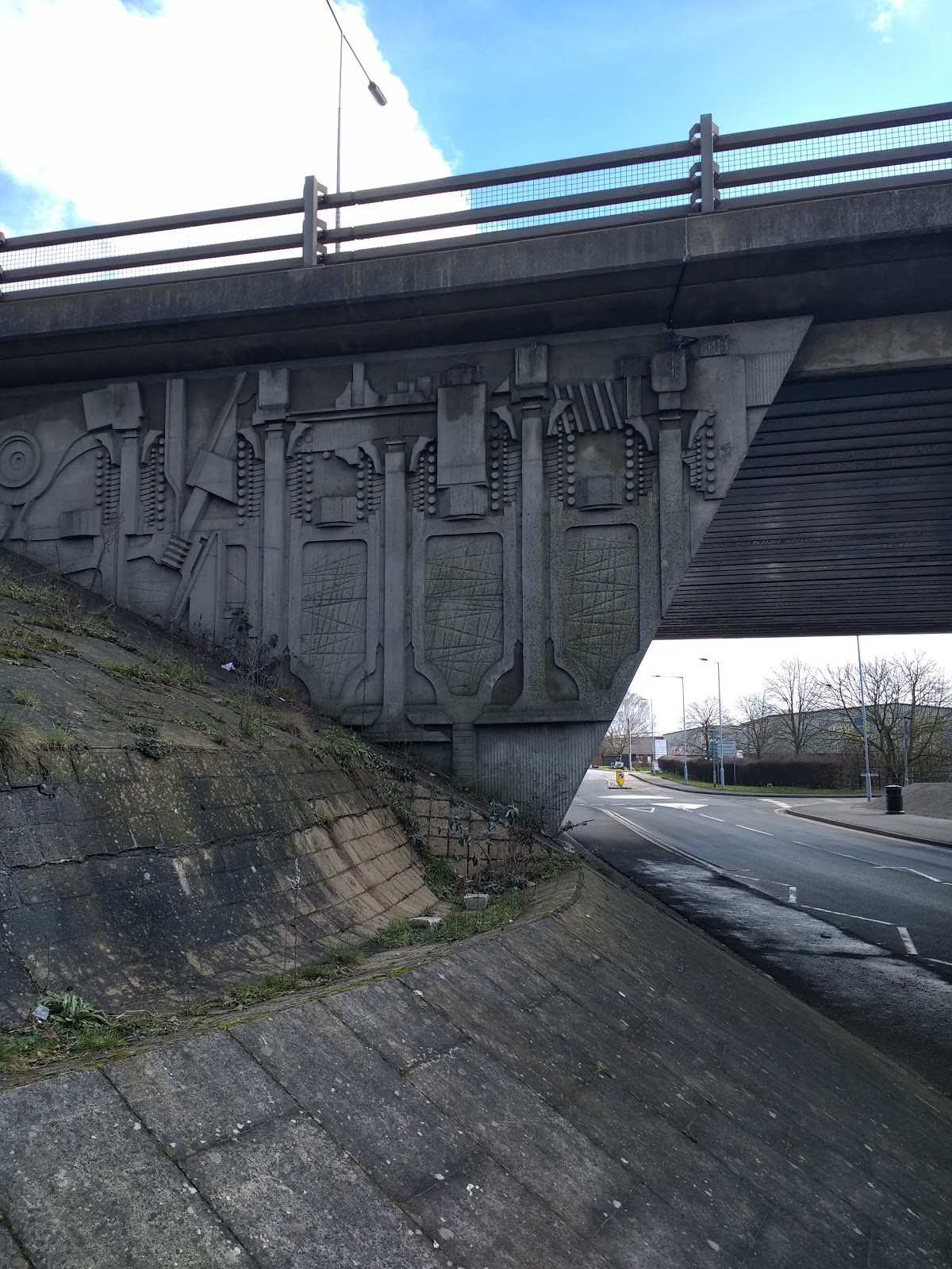
Heading East, I reached the concrete bridge going under Frank Perkins Parkway, one of a series of dual carriageways encircling the City. The road is named after a local early 20th Century industrialist who was big in diesel engines. The engravings on the bridge presumably some sort of reference to Perkins, are strangely reminiscent of Eastern Bloc brutalism. I was short on time, but the urge to pass 'through' made me abandon worry of such trivialities.


Beyond the bridge the environment changed immediately. Used car lots, MOT test centres, an industrial estate or two. Further up a dog track. A grease cafe, currently closed due to family illness. Hopefully a temporary phenomenon. A blacksmiths operating out of a bungalow. A mobile home park.  I felt I'd been teleported to a place far further out of town than I actually was by passing under the concrete bridge, both physically and metaphorically.

Eventually I managed to loop back via Boongate, negotiating a busy slip road where a footpath had abruptly and inconveniently ended, then through a residential area which turned out to lead me to Star Road. I knew where I was then and made it back, only 10 minutes late.

Sunday, 23 July 2017

Split perambulation: Croydon and London Bridge to Kings Cross

Having been sent to  Waddon for work, just a mile or two  South West of the centre of Croydon,  it seemed only sensible to get off the train at East Croydon and take the opportunity for a bit of ambulatory activity. I've only ever been to Croydon once before at the start of a walk along the River Wandle. I didn't recognise the station from my last visit. There was a lot more development going on since I was last here.

I'd arrived with the best part of an hour and a half to get to Waddon and find somewhere for breakfast. I left the station through a side exit and the vicinity immediately outside was devoid of much except for a Co-op so I kept going towards the main road (A12). Croydon is well known as being a place festooned with 60s office blocks which featured in abundance. Among these I noticed a particularly tall purplish skyscraper, a far more recent building called Saffron Square, a new residential development. It's had it's critics for it's design and for being marketed to overseas investors rather than providing much need homes for normal people (just for a change). But the height of it (43 storeys) and garish colour makes it visible from most of the rest of Croydon and probably beyond  so at least it was a handy reference point.

I walked up the main road and passed Lunar House, a large white building housing the Home Office immigration/visa centre where people wanting to apply for a visa in person have to come. Similar I guess to going to Peterborough for getting a passport but probably an even longer and more costly process. Last time I came to Croydon it reminded me a bit of Peterborough, particularly the shopping centre area. Both places are ones that are often derided. Both have been developed extensively in the 60s and 70s although Croydon much more impressively if you like brutalist architecture. Lunar House was built in 1970, along with nearby Apollo House, the names inspired by the 60s space programme. Apollo House is also the name used for the block of flats the main characters in the sitcom 'Peepshow' lived in. The actual block of flats used in filming for the exterior of their abode is Zodiac House. The green plastic looking interpretations of the signs of the zodiac above the entrance are bizarre. I don't remember seeing them in the TV show and I didn't pass Zodiac House while in Croydon which was a shame.

I'd mentioned the idea of mapping TV sitcoms based in London in a previous post and have since discovered, unsurprisingly, that i've been beaten to it. So hat's off to whoever plotted the google map. Purley, just up the road from central Croydon, was the setting for Terry and June in the 70s. More recently Croydon been the setting for a BBC 3 sitcom about the staff working in a Fried Chicken takeaway ('Fried') and for Jo Brand's comedy 'Going Forward'.

Further up the road I went past a sign for West Croydon and it felt like I was heading the wrong way out from the centre.  A quick map check confirmed that so I doubled back down a parallel road.
Masonic Hall
I thought this church a bit unusual. I didn't have time to stop and have a closer look, the need to find breakfast becoming more of a priority. A bit of post walk research revealed it is not a church but the headquarters of the Croydon Lodge of Freedom, a masonic hall.

I walked on, heading to what was referred to as the Old Town, and fairly soon came to a main road that I needed to cross to get to Waddon Road. I'd somehow managed to miss the Town bit of the Old Town or at least the bits with anywhere that sold breakfast so pressed on to the Waddon Cafe, a decent grease cafe in the proper tradition. On a corner along with a handful of other shops/takeaways that are facing a Morrisons over the road (not one that sells breakfast).

Meeting over, I headed back to East Croydon through suburbs after turning off at random somewhere on Purley Way. I followed a road alongside Duppas Hill, Croydon's first recreation ground and previously site of the Croydon workhouse. I was tempted to walk across it but this would probably have taken me in the wrong direction..not normally something that would worry me too much but I was a bit restricted on time.
Prior to crossing the A232 I passed these dilapidated looking garages. The doors didn't look quite right, as if they were made from cardboard.
Croydon subway underpass
Taking the  underpass crossing the A232,  I made an educated guess and came out in roughly the right direction to head back into the town. Not much further from here I passed a pub. It wasn't opened and it may not have been in business any longer. The frosted and patterned windows made it impossible to glance inside to see. But once all pubs were like that, offering uncertainty to the non-local as to what (and who) might be found inside. More often than not now it's possible to look through the window before going in. On the plus side allowing a look at the beer range is half decent and t check that the company looks convivial. In some ways this is a good thing but it also means the windows are more boring and customers are on show in the manner of a goldfish or shop mannequin. For anyone trying to maintain a low profile (bunking off school/work, hiding from your husband/wife/mum/Dad/the Police) or for the innocent just wanting a bit of peaceful solitude this is not ideal. For the onlooker any wonder and imagination about what might be going on inside is lost. I remember walking past pubs when I was young and wondering what could be going on inside and why I wasn't allowed in. Similar (but not quite as interesting) were bookies with their beaded curtains. The possibility for these sort of imaginings is fast disappearing.
I knew I was heading back towards East Croydon when I could see Saffron Square looming in the distance like a purple a beacon.
Croydon Towerblock


Nestle brutalist
Walking along George Street I noticed the Nestle Tower, an impressive enough piece of 60s brutalism. Nestle (always pronounced 'Nessels' by people I knew when I was a kid) vacated the building 5 years ago and it's been purchased by Chinese developers with, unsurprisingly, a view to residential conversion

I was quite taken with Croydon as a place to explore, something I would do a bit more of when I had to return to Waddon a couple of weeks later. It is obviously a place in the grip of gentrification but still has plenty of so far unaffected areas in the centre. As well as the 60s architecture and  older buildings there are plenty of regular shops catering to the 'ordinary' person. A Lidl on the main drag and a Wetherspoon (I passed one - there may be more) as well as plenty of independent shops selling things that are useful shops. It hasn't been heavily populated by Nathan Barley types or beardy-man-bun clones just yet. Maybe worse, that phase of gentrification may be bypassed or fast tracked- straight to the really weatlhy, most of which invest in their flats- rather than live in them.
Funeral directors Croydon
In the approach to East Croydon the presence of the clock in front of J R Shakespeare Funerals serves as an ominous reminder of the relentless march of time.  Clocks are not uncommon outside funeral directors, an obvious choice of decoration I suppose. This one is also handy to check if you are about to miss the train. 
50p buidling
The 50p building
The iconic  'No 1 Croydon' building is just past the station.  This is more informally known as the 50 p building, the three-penny bit building or the wedding cake. Formerly it's proper name was the NLA building (NLA standing for Noble Lowndes Annunities- no, I've never heard of them either) when it was put up in the 60s. It featured in the opening credits of Terry and June and was later called one of the UK's top eyesores in a programme on Channel Four (around the time it underwent a refurbishment).
Croydon gentrification
View from the Boxpark
I was in need of refreshment before getting the train and luckily there was an outlet for excellent local brewery The Cronx right next to the station. This was part of  a complex called 'Boxpark' which appeared to be a temporary structure containing various food and drink outlets with a large area in the centre to sit and eat whatever food you have bought there. This was I suppose a typical example of hipstery gentrification but it's temporary nature indicated it was soon to be swept aside for development for the benefit people further up the food chain of the gentrification hierarchy and this re-enforced my earlier perceptions.

One of the outlets, selling meaty products and bourbon, had artwork depicting people with animal and skull heads. I'm not sure what this was supposed to signify, if anything. Maybe the skull in the suit is meant to represent something about cultural death with the coming of wealth. But it's probably just supposed to look cool - and it did I suppose.
Psychogeography Croydon


Croydon psychogeography


The train back travelled back through the wilds of South London, places unknown to me or only briefly passed through like Norwood Junction and Penge West. Back through slightly more familiar territory of New Cross Gate. Then the City of London looms into view.


View from the train Psychogeography
I headed back in the rough direction of Kings Cross.
London Bridge and the Shard
This was Southwark Cathedral (I think) with the Shard in the background. The mix of old and new in this part London, as elsewhere, is stark and moreso since the Shard was put up. I've never really been tempted to go up it despite the spectacular views from what is said to be the tallest building in Europe. It's about £25 to be being granted access to the specatcle, probably involves queing and I'm not really one for heights. Prior to it being complete it was 'hacked' by urban explorers. Theres a good article about that here.

Further along somewhere past St Paul's Cathedral I passed this building. It's been a Youth Hostel since the 70s and was previously St Pauls Choir School. I was drawn to the Scallop Shell motif. The scallop shell has been used as a fertility symbol asscoiated with the Roman Goddess Venus. It's also been used as a symbol for religious pilgrimage. More recently of course for Shell Oil. I don't know what the intention of  the architect was here but my feet were telling me I was making a pilgrimage of sorts..albiet one with no religious intent, much direction or anything in mind to revere at the end of it.
Psychogeography Shell Motif
Nearby a crow or possibly a rook, I'm never sure. The saying goes 'if theres more than one crow they are rooks, if theres only one rook it's a crow. So I'm going with crow. Crows have been associated  with death and the 'other world' in Britsh Folklore. While I didn't think mortal danger was imminent I think crows do have a bit more mystery and command more respect than pigeons even when scavenging on bits of dropped sandwich. Further east, Ravens, which are larger versions of crows, reside at the Tower of London. It's said that if they leave England will fall. I think their wings are clipped to make sure they don't fly away.
Soon after this after passing the Old Bailey, I found myself at the corner of Guiltspur Street and Cock Lane. Here the Golden Boy of Pye Corner marks the point where the Great Fire of London is said to have stopped. This was orginally the site of a bawdy pub. Probably not unconnected is the blaming of the fire on the sin of gluttony, as described in  the enscription on the wall. Being on the edge of the City, the epicentre of greed in London, any warnings of future restraint have fallen on deaf ears but there's been no repeat of the fire - yet. I'd never heard of the somewhat defiant looking Golden Boy before. He reminds me of a post-piss version of the Manequin Pis in Brussels, mocking puritancal warnings about gluttonous behaviour having relieved himself in the street. I'd seen the name Pye Corner on a map of Harlow before and had imagined the name derived from the location of a former Pye electronics factory, possibly now derilict. I'd wondered if this might be the inspiration for the electronic music artist known as Pye Corner Audio. Probably not. Of course 'Pye' is an old spelling of 'Pie', hence the association with gluttony. There are several Pye Corners in the UK. The character 'Neil' in 'The Young Ones' had the surname 'Pye' so theres a tenuous comedy link there..
London Psychogeography
Somewhere a bit further along near the Barbican was this mural/street art. It seems to depict a young person with an affinity for the animal world. A hipster version of The Beastmaster or Johnny Morris perhaps.
Gentrification Hipster
Then I found myself on Goswell Road which leads from Barbican to Angel. Somehow I'd never heard of or walked along this road, despite usually ending up on the almost parallel routes of City Road, Farringdon Road or Grays Inn Road on meanderings back to Kings Cross from central or  Eastern bits of London. This was nicely disorientating. I felt like I'd slipped back in time to the 1970s London of  the Sweeney and Minder. The front of the establishment pictured below features the Pepsi sign once common on places with names like 'Jim's Cafe'. This conjured up images of formica, silver foil ashtrays, plastic tomatoes, cheap and basic grub (fry ups, liver and bacon, shepherd's pie) and Crusha flavoured milk. A mixture of memories from TV programmes and holidays in Yarmouth and Cromer as a kid.
London Payschogeography Cafe
Further along the road is Turnpike House. I immediately thought of the LP 'Tales from Turnpike House' by St Etienne and it's cover featuring what I thought was this tower block on the front. Except on checking this out the album cover I was thinking of was for their 'Finistere' LP which features the image of the tower block Ronan Point in East London - just before it was pulled down. When I first heard the title of the LP, to confuse things more I'd assumed it was about somewhere in Turnpike Lane. The London Trilogy of films the band made with director Paul Kelly are esssential viewing but I've never really listened to any of the bands music properly. This would probably explains my confusion around album covers and locations. Kelly resided in Turnpike House when collaborating with the band on one of the film'What Have you done today, Mervyn Day?' The Turnpike House imagined in the album and it's songs of kitchen  a sink drama was as much inspired by suburban areas as the actual location including Croydon, bringing things back to the beginning of my walk.
Turnpike House Psychogeography
Despite being named after a place in France, St Etienne have definate London and psychogeographical connections.  One album is  called 'London Conversations' and another,  'Words and Music by St Etienne' features an image of a fictitious A-Z style map with street names made up of the bands favourite songs. Bob Stanley of the band is quoted as saying ''the idea is that you can follow roads on the map and end up with a playlist of different journeys. There are 312 song titles on the map—it's our hometown." The most recent album is called 'Home Counties', traditionally a place where people end up moving to from London in middle age, motivated by suburban/rural ideas of  more space, peace and quiet and a perception of a safer place to bring up children while putting up with an extended commute. Whether this is still as prevalent and has happened to the members of St Etienne in recent times I'm not sure.

Turnpike House date from 1965, part of the Kings Square Estate built on behalf of Finsbury Council. The estate is currently undergoing development to include 70% 'affordable' housing at 'social rent'.  Judging by the number of hits for estate agents adverts a search for 'Turnpike House' produces I doubt that many of the original flats still fall into that category.

I diverted East somewhere before reaching Angel before heading to City Road and across to the excellent Wenlock Arms for light refreshment and a sit down. The pub dates from 1835 and now sits in a conservation area following an earlier attempt by delevopers to demolish it. On a previous visit some years ago me and some friends were accosted by an excitable and slightly incoherent French woman telling us something about the pub being under threat and that she thought she'd have to start drinking in the pub near the Eye Hospital instead. She need not have worried about the pub but Wenlock Road is almost unrecognisable since the first time I visited, probably about 15 years ago. The pub acts as a symbolic and physical buffer against more 'beige' development spreading any further along that side of the street. It featured in the Simon Pegg film 'The Worlds End', which was set in the fictional Newton Haven, nothing to do with London or it's numerous pubs of the films title. The Wenlock also featured in the opening titles to a comedy quiz show on Dave, presented by Al  Murray with the dubious sounding title 'Compete for The Meat'. On the programme people compete for a frozen chicken, with a second prize of some sausages while Al Murray hosts it in his 'Pub Landlored' character.

Across the road is Shepherdess Walk Park. I'd never walked across it and decided I ought to. I was drawn towards the mosaics in one corner of the park which depicted the seasons. One is labelled 'Hackney 2012'. The first mosaic in the park was created that year in celebration of  life in Hackney's parks during the the olympics. Here, nearer to the border between Islington and Hackney it is four and a half miles from the actual Olympic Park but it feels a world away.

Mosaic Olympic Park
I exited the park through an alleyway which lead into the street containing a former pub. The Blockmakers Arms closed in the early 80s. I wonder how many people have stumbled towards it since only to realise that. I guess the occupants get a few random and unwelcome visitors too. Having already refreshed myself at the Wenlock I wasn't one of them.
Closed pub psychogeography
Regents canal psychogeography
I walked back in the direction of Angel and Kings Cross along the canal, where as a pedestrian ot makes a nice change to be given priority. Although not everyone agrees evidently. On the canal path the pedestrian has to coexist with a high volume of cyclists and joggers (I don't think they count as pedestrians). In the main this isn't a problem, but joggers do sometimes seem to assume superior status over slow(er) paced wanderers and ambulators who they expect to always step aside for them. They are not prepared to stop or move aside and insist (not vocally-it's just a given) that it's you who must instead. So even in a car free environment the walker is still seen by other 'modes' as at the bottom of a mode of travel/movement heirachy.
I was quite happy to slow down in the light of this and besides wasn in no rush.

Along one of the side roads leading into Upper Street I noticed the coffee shop above. The name Daily Grind was a good pun, recognising one of  the main reasons for the success of coffee shops is the few precious minutes of solitude and peace accompanied by a caffeine boost they offer on the way to work. The interlude between being half awake and coming to life before enduring another working day.
After eating in the always good Indian Veg I walked back to Kings Cross. Uneventful save this window. Kogan Page was a book publishers but it looks like they are closed and the building is being used as a temporary art space or squat. There was a train to Cambridge due so I didn't hang around to look closer. When I'm next here I'll see if it's still there, but my guess is it wil have been 'developed' into something else by then.