A few weeks ago my mum mentioned parking up with her late husband in a small street he called Gas Lane, near to the Mogul Tandoori in Sturton Street (Cambridge) where they were picking up a takeaway curry. I'd never heard of Gas Lane. I'm familiar with the area, so wondered how I could have missed this small side lane of which she spoke. Of course there could have been confusion regarding the street name but the idea of a small lane which somehow I'd missed despite living in Cambridge most of my life was intriguing. The name 'Gas Lane' conjured up images of miasma-like fog, gas lamps, Victorian Houses and Victorian men wearing top hats and cloaks lurking in the half light. A lost ghost street, existing in parallel with modern Cambridge. Not on google maps- a sort of reverse
Argleton. I resolved to explore the area properly on foot and see what I could find.
The vicinity is part of what is known as 'Petersfield', over the other side of Mill Road Bridge from Romsey Town. I started at the corner of Gwydir Street and Norfolk Street.
Roll On Blank Tapes has been there so long I normally wouldn't take much notice of it. Closed since the turn of the millennium, it is a mystery how the building survives in an area of such preposterously high house prices. When I used to visit to buy blank tapes in my youth the proprietor struck me as a bit of an odd man. He use to emerge from a back room and seemingly rarely left the premises, although somebody claims to have seen him working in Tescos on Newmarket Road since. There were rumours of the shop being a front for something dodgy - drugs, porn, prostitution. Here on an old
'We're All Neighbours' thread somebody says it was used as a location for video/photo shoots for 'Micropenis' and 'The Redemption'. I haven't been able to verify if this is true or what these videos/photoshoots were for. An quick search for 'Micropenis' on google produced results that were somewhat unsavoury, particularly at breakfast time, which prompted me to abort my researches. My feeling is that any claims of dubious activity are likely to be unfounded. It's been said elsewhere it was owned by the much respected
H Gee on Mill Road, an even more incredible (and still open) throwback to a past retail age selling a mind boggling array of dusty electrical items.
Over the road, the former
Prince of Wales has been in residential use for as long as I can remember. The revived ghost sign, which has been that way since at least 2008, is something I've never noticed before. Just goes to show it's worth looking up (or down or sideways) as well as straight ahead. I'm not sure about reviving ghost signs. I think they should probably be left to slowly fade away in peace.
The old St Matthew's School building above is now also a private residence. Or maybe multiple residencies. There are separate doorways for Boys and Girls as on most school buildings of this era. The notice warning stone throwers that they will be prosecuted seems like something designed to warn against guerrilla attacks by disgruntled schoolchildren, who were no doubt subjected to the horrors of Victorian discipline and the brutality of corporal punishment. But it might just be a twee joke by the new owners.
Just up the road is another building I often pass but have never paid much attention to. Alex Wood Hall is the local Labour Party Headquarters. Cambridge, and particularly Mill Road is more labour than anything else in political terms. But it's over the bridge in Romsey and the site of the
Labour Club (now closed and likely to be demolished before turning into Cambridge's next instalment of luxury or student flats) that I associate with the Labour Party in Cambridge. Romsey was known as 'Red Romsey' or 'Little Russia' in the early 20th Century due to being populated by heavily unionised railway workers. Both my maternal grandads (the blood-related one killed in the war, and the grandad I knew, my mums step dad) hailed from the area and had frequented the Labour Club which their fathers had helped build. I wondered why the Labour Party Headquarters had ended up over the bridge, away from Little Russia. Maybe it symbolised the shift away from real Labour towards New Labour.

Away from politics (which is probably the best direction) a few feet up the road is this display of preserved creatures in someones front room window. I stood and enjoyed looking at them for some time, having previously only glanced at them in passing. I wondered if the house owner was some sort of academic or scientist specialising in the study of these creatures or if collecting them was more of a hobby, rather like a bit like a grown up version of the collection of plastic and rubber insects and dinosaurs I accumulated as a kid. A quick google search later revealed numerous websites sell these dried insects, the most directly named one being
deadinsects.net.
I decided I'd been loitering long enough on the fringes of the zone in which Gas Lane might be found and began my search. Above is a parade of shops which runs along one edge of a housing estate which was built on the 60s as one of Cambridge's first slum clearance projects. The pub now known as the Blue Moon, but most well known as The Man on The Moon, was part of this development and looks typical of 60s/70s estate pubs. It was opened in 1969 and the name refers to the space race of the time. A couple of weeks earlier I had noticed the car park that backed onto the shops was due to be demolished. This had already happened on my return.
Behind the car park was a footpath, which I had planned to walk through but access was denied due to the demolition.
So instead I crossed the road and walked down Vicarage Terrace almost directly opposite. This seemed the path of least resistance and would lead to the Mogul Tandoori. This road had been in my minds eye when my mum first mentioned parking in a lane near here, before mentioned the name Gas Lane.
At the top end is the garden of The Parish Church of St Mathews which dates from the Victorian era. This gives way to some more modern housing further along and other more recent developments. This utilities box featured my first sighting of the day of 'Nigel' tags. These pop up frequently around Cambridge seemingly at random. It has the distinction of being a tag that is clearly legible, although the significance of it, or who Nigel is, remains a mystery. Nigel has been around for quite a while, suggesting a tagger of advancing years. About a year ago I saw the same tag in
Berlin at the Humboldthain Flack Tower. Maybe Nigel gets about a bit. Or maybe it's a franchise, with a Nigel in different locations. Or maybe he doesn't exist at all and it's just something replicated by lots of different people in Cambridge and other places.
The signs warning non-residents against parking ranged between the politely threatening 'we may take legal action' to warning of a dangerous encounter with a hairy wheelchair or it's owner. I doubt my mum and her husband would have risked that, even for a curry. This ruled out the street as the 'Gas Lane' to which she had referred.
I'd not heard of The Metropolitan Housing Society before but it appears to have taken over or joined up with Granta Housing, a local housing society set up in the '60s. Private housing in this part of Cambridge is inextricably linked to London with prices to match, being within walking distance of the station and commuting . Plenty of landlords from London rent out gaffs in the area too. So it shouldn't be a surprise that social housing isn't immune to a metropolitan influence as well I suppose.
I emerged from Vicarage Terrace opposite the Moghul Tandoori and the
Dobblers Inn. Another thing I'd not noticed before; the Dobblers unusual facade. It looks like they started to build the left side with two floors, then decided against it, the one storey necessitating the taller than normal chimneys. It's not a pub I've visited much, being slightly at the wrong end of the real ale triangle (or maybe Octagon, I haven't mapped it) of pubs off Mill Road for me. Both in location and propensity for TV football. But it deserves respect for maintaining old school pub activities-pool, darts, pub quiz, etc which are lacking in other establishments in the vicinity. I've only been to the Moghul once in my life too, a long time ago. It's reputation is very good. But that's on the wrong side of the curry triangle. I'm almost certainly being topographically inaccurate with my triangle analogies. But it is very easy to lose track of time and effectively disappear, at least for a while, in one or more of the areas pubs and /or curry houses. They represent an urban Bermuda Triangle without Barry Manillow music and have never to my knowledge appeared on an episode of Arthur C. Clarke's Mysterious World.

 |
| Vicarage Terrace from the pub end.. |
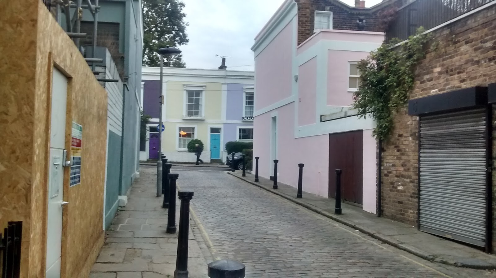
Round the corner from the Dobblers is Abbey Walk. Much of this is new housing, but built in a similar style to the surrounding Victorian dwellings, if slightly grander looking. There are some older houses round here too, but I was certain this was not Gas Lane as described by my mum or otherwise.
It was here that I saw the second of the days 'Nigels'.
I had a rest on St Matthews Piece overlooked by the Weyman Funeral Home and Strawberry Cottage. On it's
Wikimapia page, the Piece is remembered by someone who played their in the 50s when they were at St Matthews School and that
'it sure looks country now, it used to be half paved with swings, climbers etc'. Their are still swings and roundabouts but they seem much tamer than those that would have existed in the concrete age of the 50s. Over the other side of the piece is the building that used to be the Howard Mallet Centre. I used to go there sometimes went I was about 10 years old but memories are vague. I'm not sure what we really did as members of the 'Howard Mallet Junior Club' except hang about in the tuck shop and on the Piece. There would have been concrete then too, I'm certain. Vague half memories of this time/place are a posh girl from Perse School who dressed a bit like a man and smoked fags, and a kid who looked like Augustus Gloop from Charlie and the Chocolate Factory. The same people went to the nearby Carioca Club junior disco which happened in afternoons of school holidays. Beating Augustus Gloop at pool, Ghost Town by the Specials being heavily featured on the disco (a la Father Ted) and prawn cocktail crisps with Worcester sauce are my only clear memories of the place. The internet seems to have largely forgotten it too. The only reference I can find is on
Ian Kitching's website. The club ceased business after burning down in 1986. It was the subject of complaints from nearby residents for some time before that, and attempts to open another nightclub nearby were thwarted by nimbys. I bet local legend
Disco Kenny was a regular visitor to the Carioca but nobody I know seems to remember it.
My mental perambulation into a half remembered past complete, I got up and headed back in the direction I had come, down Geldart Street which runs parallel to Vicarage Terrace. And past the other side of
The Parish Church of St Matthew and it's bizarre octagonal tower influenced by Ely Cathedral.
The vicarage is a more modern building and the road generally has a post war feel to it building wise. Clearly this was not or had ever been 'Gas Lane'.
Opposite the church, I was back at the estate with the demolished car park. I'd never walked into the estate before and I was curious.


The flat roofed buildings, colour of the bricks and general layout of straight passages and right angles reminded me a bit of the much newer and more upmarket
Accordia development across town on the former Government Offices site. Both had won design awards. But the contrast between the two places was also stark. This area still has the feel of the 70s council estate it was, although some dwellings are being let at rents far from council these days. I've no idea of the demography of the estate now. I didn't see anybody apart from a brief glimpse of a man with a bull terrier type dog. It felt like I had gone back in time to the estates I used to play in/walk home from school through. It seems incredible that it could still exist so close to the centre of contemporary Cambridge. The names of the streets/walkways are largely Gaelic sounding - Donnegal, Farran, Inveran and , er, Enfield. No Richard Rogers Way around here. This was somewhere from the past while Accordia represented a possible future (although not that possible, unless you are loaded).

The recent(ish-2004) Crown Court building on East Road looms up beyond the tree in the picture in a slightly menacing way. Further down are four storey blocks of maisonettes and flats that would have been high rise for Cambridge in the 70s. The view through this walkway shows the former BHS on the end of the Grafton Centre shopping centre over the other side of East Road. An 80s development built after 'slum' housing was cleared in the area known as the Kite. At the time I can vaguely remember the campaign to 'Save the Kite' on local TV and am convinced their was a World In Action programme about it. But this may be a false memory, I can't find any reference to it anywhere.
There seemed to be several notices saying 'No' to something or other- No Flytipping, no cycling. And no leaving it for someone else to clear up. What beast(s) the 'it' was expelled from is not clearly stated but judging by the magnitude of the deposit probably ones that are dangerous and to be feared.
The notices didn't make clear the penalties for any breach but this door looked ominous. Although attached to a car park under the flats, I couldn't rule out a secret route to the cells of the Crown Court..or worse.
What was behind this smaller blocked opening? The lair of the beast producing the unsavoury emissions depicted in the 'bag it, bin it's poster? Or a cell for those serially disobeying the commands of the numerous public notices? I left the estate without finding the answer..or Gas Lane.
The other side of St Matthews Street I decided to head down New Street. The 'Cambridge Utd' referred to on the sticker below seemed unlikely to be the football team judging by the St Georges flag. Ominous.
The other side of the road was a new bit of Anglia Ruskin University which appeared a bit wibbly. This extends along the road while opposite is what is left of the light industry buildings that used run along the road, some (or possibly all) of which belong to Mackays, a large hardware/ tool/engineering trade shop.
I was curious as to why 'this gate will not fully open' when '24 hour access' was required. And what was behind it.
Pedestrians were clearly discouraged from trying to find out less they risk being eliminated between midriff and back of right knee.
I risked a peak through the gate. The reception up the stairs at the back of the yard had the air of being somewhere you had to be in the know to get in, like a gambling den or an afternoon drinking club. The sort of place you'd get on an episode of the 80s TV series Minder.
Nigel made another appearance-larger this time and in a different font. And underneath an oblong of white painted brickwork that remained unexplained.
A little further along some of Mackay's wares were being advertised.
BOC supply a mind boggling array of industrial gases, food preservation products, foam blowing agents(?) and the like. I have no idea what most of these products are or do with the exception of dry ice.
The blue building below was once the
Rodney Brewery Tap . The sign makes reference to E Lacon & Co Limited. Lacon's Brewery (based in Yarmouth) seemingly bought Rodney Brewery's pubs. Lacon's Brewery were still around in the 60s. A bloke I used to get the bus to work with telling me of the boozy weekends of his youth, recalled avoiding one particular pub due to it being a Lacon's house and their beer being 'terrible'. Lacons weren't around by the time I was old enough to go to the pub but have in recent time re-emerged. I've not tried the beer but by all accounts it's good. About the Rodney Brewery I can find little else. It gets a brief mention in the undoubtedly essential 1916 publication
the Gravels of East Anglia. But that's about it . The Brewery History Website says it is now a house, but it looked more likely to either be part of Mackays or the CATS College which has a small building next to it. CATS College is a sort of Sixth Form/access college for overseas students hoping to get into Cambridge University. Opposite this building is new student accommodation in the standard bland style (let's call it beige) that the people of Cambridge have come to expect from developers as more and more of it gets built.
Also opposite is the building that used to be the aforementioned Howard Mallet Centre. I don't recall the building being so 'glassy' when I was a kid but I'm pretty sure it's not been demolished and rebuilt. It was always a community centre, and has gone through several incarnations. The land was
'given to residents in perpetuity for rest and recreation'. But it was sold to developers. The building was due to be demolished and looks different in this publicity from the
developers Chard Robinson. They were due to lease the building to the local Bodyworks dance school but it seems they changed their minds and instead let it to the Cambridge Education Group who use it as premises for their Cambridge School of Visual and Performing Arts. The same group own the aforementioned CATS College and the students will presumably be from similar backgrounds (from rich overseas families). At some point in the recent past the building was renamed Citylife House, just as links with the city and it's life and community were seemingly about to be severed.

On the opposite site of the road in front of yet more monotonous 'beige' development, I was struck by the juxtaposition of the four black and white seriously concerned faces in the anti-brexit poster, and somebody dancing around with colourful broccoli apparently without a care in the world. Opposite a former community centre now teaching dance (possibly including the use of broccoli) and is now a lot less, if at all, accessible to residents.
I diverted down Abbey Street towards Newmarket Road, where what was the
Five Bells pub still stands. There are several ex light industry buildings on
Abbey Street in various states of emptiness/dereliction. The Five Bells has been shut for several years but it could be due to
re-open. My only visit was on a pub crawl about 25 years ago on a Friday afternoon. I remember it as being a slightly unfriendly and possibly dodgy pub with about three middle aged men in it. They tolerated us while we stayed for a pint and played pool but the atmosphere was distinctly uncomfortable. Later it became a gay pub and lasted a few years before it closed. I have a vague memory of my Dad stopping the car outside when I was a kid and going in to see someone. My memory tells me he was renewing a fishing permit or something but I can't think how the pub was connected to fishing..
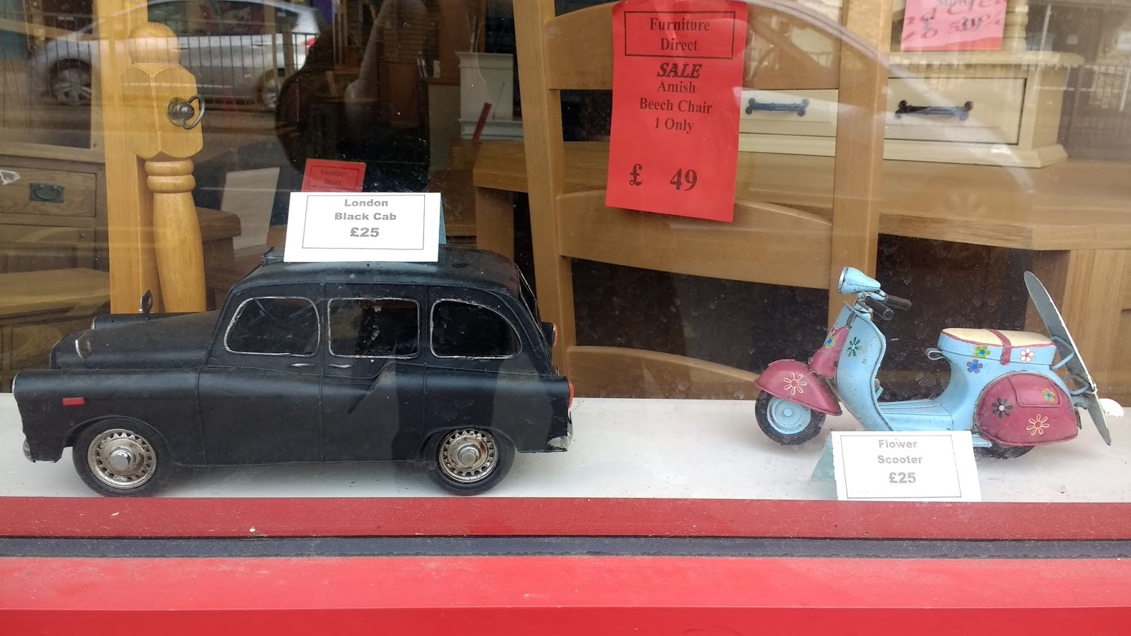
Past the bus stop are a two or three shops. One is currently a pine furniture shop which has a sideline in model taxis and vespas.
On the corner of Newmarket Road/East Road at the edge of the Elizabeth Way roundabout, is the former
Rose and Crown. The original rose and crown symbols on the wall, joined by the Greene King motif and latterly the Cambridge Property Lettings sign, made the building look like the headquarters of some sort of mystic society. I'd always assumed 'Rose and Crown' referred to the
Rosicrucians. I'd read something about them years ago but couldn't remember the details. The
Rosicrucian Order of AMORC say they are 'a community of mystics who study and practise the metaphysical laws governing the universe'. The wiki page lists a plethora of 'orders' linked to Rosicrucianism including the Golden Dawn and there are links to Freemasonry. However, I was wrong about my assumptions. The Rose and Crown pub name/symbols are to do with the War of the Roses when Henry Tudor united the Red Rose of Lancaster with the White Rose of York by marrying Elizabeth. This explains the absence of any 'Rose and Crown's in Scotland. More immediately the symbols on this Rose and Crown seem to represent the focus of the building shifting away from beer and community, towards property, money and exclusivity.

A bit further into East Road there is a development of student flats. This has been here a while. I'd always assumed it was for Anglia Ruskin Students with the main University building being up the road. But a plaque on the building showed at least part of it was being used by CATS college. Another part of the building was currently empty and up for let. Maybe people are put off by the wallpaper.
Next door is Ace Motor Sales which looks very reminiscent of Arthur Daley's car lot in Minder. The older, undeveloped bits of this area in general reminds me of the
locations in the TV programme, which always fascinated me as much as the dodgy characters it featured. The reception mentioned earlier was roughly behind the car lot from this angle.
 |
| A little dodgy, maybe? |
Next door is the front entrance to Mackays. I was invited to take a selfie with Dickie Mackay. He looked a bit creepy to me and I declined the offer.
As well as Ronseal, stanley knives and BOC industrial products (some possibly highly flammable), fireworks are available all year round.
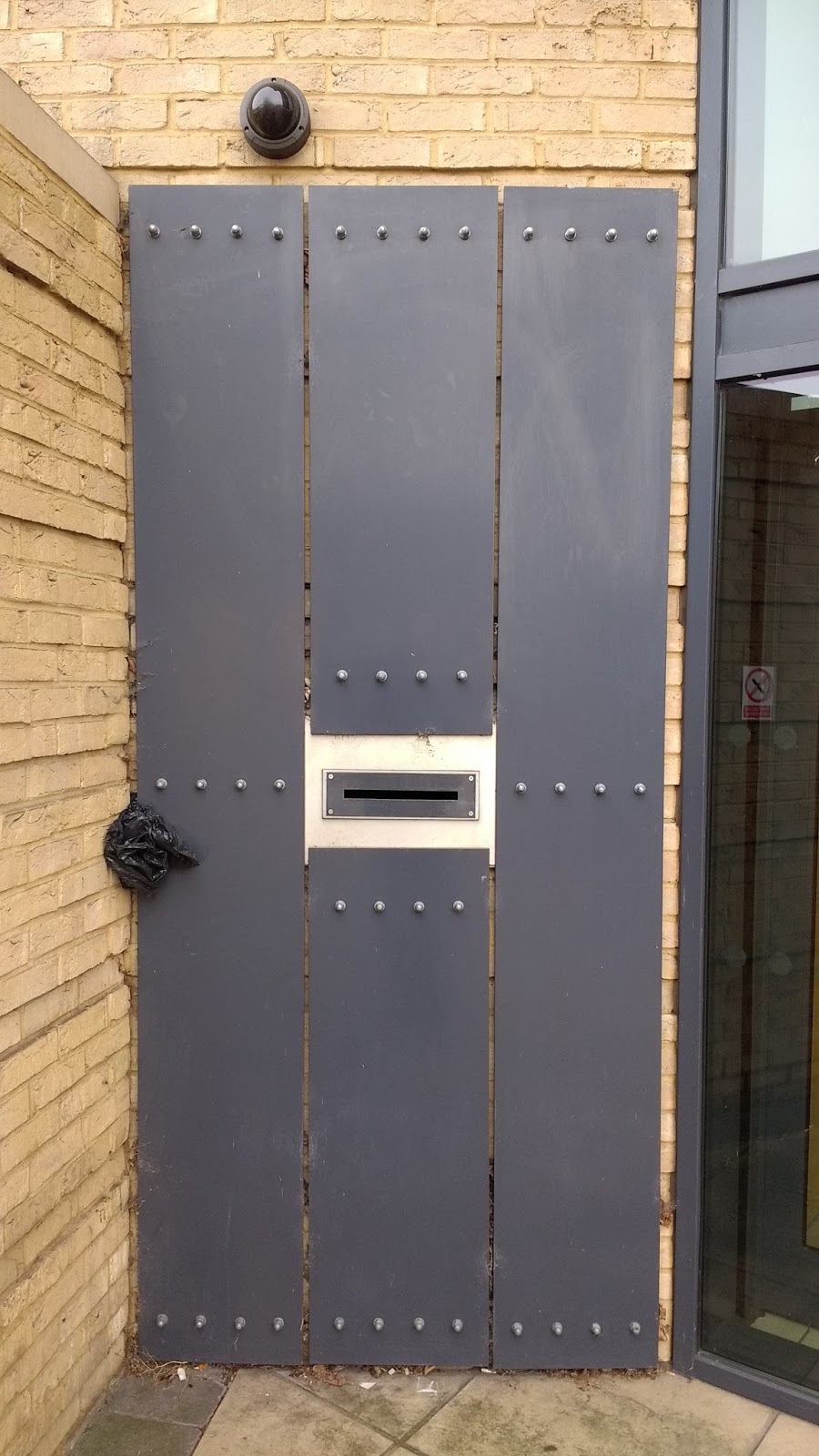
Next door was the other end of the passage I'd passed on New Street. With the same ominous anti-pedestrian sign. The 'pedestrian' reminiscent of 'the incredible shrinking man'. This was close to the County Court.
And this door which presumably is the criminals entrance.
I headed into the underpass to the underneath of Elizabeth Way roundabout. Cambridge doesn't have a lot of 60s concrete underpasses, but the roundabout has four leading into it.
The theme of the unofficial street art was somewhat skeletal.
The official street art consists of murals dating from around 2000 in each of the four underpasses. Apparently they depict various Cambridge subjects associated with the direction of the road each underpass leads to. The one below appears to represent the River Cam.
Unofficial street art wasn't all skeletons. This, I think, resembles a ghostly Mr Greedy wearing a jetpack. Which is sort of beautiful I suppose.
Then there was carrot woman.
Under the roundabout is a space where people on bikes and people on foot can rub along (in the most part) nicely, while then traffic circles overhead. I stopped and sat down for a while. I'd never really hung about here for long before and appreciated it as a public space.
Unofficial and official skeletons (above and below).
I took the underpass out onto the other side of Newmarket Road. The mural here shows
Stourbridge Fair. Stourbridge Common is about a mile away between the river and Newmarket Road in this direction. The last fair was in 1933, after an 800 year history having begun in order to raise money for Lepers at the nearby Leper Chapel. Recently the fair was revived and I visited it a couple of years ago. I'd always imagined the original Fair as somewhere rawkus and unruly with drinking, music and probably bear baiting or cock fighting. The new version is considerably twee-er than that. The Luton Town fans passing on their way to the Abbey Stadium opposite were the only vaguely ribald element. The Leper Chapel was open for inspection and tea and cake though, so I wasn't complaining.
Through the other side of the underpass the unofficial street art returns.
A bit up Newmarket Road is the Cambridge Oddfellows District Office. I'd often wondered what exactly the
Oddfellows were, assuming they were some sort of poor relation to the Masons. They are indeed a fraternal society along the lines of the Masons according to Wikipedia although the explanation in the window doesn't sound quite as mysterious.

Across the road, an example of the new development that is growing up along the road next to the old 60s building housing Cambridge Refrigeration Technology. Belvisi is a posh furniture shop. There are flats above known as 'Evening Court'.
Back on my side of the road I noticed a yard and house with what appeared to be an explanatory plaque of some kind. The wording claims
'between 1963 and 2009 here in this yard Don Casey invented, made and launched many objects used for solving small and world problems'. Notably the 'Filchie Clip', which the plaque says gives choice and independence in individual personal lives. The Filshie Clip (correct spelling) is a device used in female sterilisation co-invented by Don Casey. I suppose the wording on the suspiciously new looking plaque sort of alludes to this but why the crypticsim? Maybe because the house appears to have been split into holiday rental apartments, catering to those fairly well off judging by the prices, and the pedantic judging by the reviews '...everything we could possibly think of (except a bread knife)'. Nobody seems to have pointed out the incorrect spelling of Filshie Clip though.
The carving below is from the
Church of St Andrew the Less, also known as Abbey Church. The figure struck me as somewhat moody while also decrepit but strangely mesmerising. And looking not unlike Lee Van Cleef in 'The Good, the Bad and The Ugly'. The church is now locked most of the time but in occasional use. It was originally provided by the excellently named second sheriff of Cambridge, Pagan Peveral, who had been given the Barnwell area by King Henry in the eleventh century and presumably would have had involvement in the Stourbridge Fair. The Church, although not immediately striking, is one of the more interesting features along this stretch of road, which is threatening to become increasingly banal each time a new build goes up.

Just up from the church I passed the unassuming looking Cambridge Seminar College. This appears to be another sixth form crammer college aiming for the overseas market judging by the website. It's housed in a building of similar vintage to the Refrigeration Company, called 'Logic House'. The sign outside makes reference to 'Veritas' which means the Truth. But the word was also the name of the short lived UKIP splitter political party led by Robert Kilroy Silk. Kilroy Silk started his career as a university lecturer in the 60s and 70s and he seems to have disappeared since the fiasco-ous and much lampooned 'Share or Shaft' quiz show he did. Surely they wouldn't employ him here?
The sign over the road on a new block of flats (sorry, apartments) that are verging on the beige style, declares 'Let us be all we can be.' This had a sort of Orwellian oppressive feel mixed with the sort of fake optimism beloved of housing development advertising. The name of the development, Beacon Rise, seems to indicate light rising from the darkness..nobody passing seemed to notice or be impressed.
Across the street was barren plot that has been acquired, what was there previously already forgotten (at least by me) and ready to rise up as the next beacon of cardboardy looking flats/retail opportunities. A little further along Coopers furniture shop is a relic from an earlier age with it's blue mosaic-like tiled background underneath the name. Facing off the Travelodge across the road, making a final stand.
Next door West Garage has gone and Watkin Jones promise to be building the future in it's place. I imagine this is likely to be contemporary student flats I rather than some sort of exciting futuristic construction. Hopefully I'm wrong.
Over the road there used to be a very unusual dark glass building housing offices of some sort. A friend had worked there, saying in was insufferable in summer. Nobody was that sorry to see it go but whether it's replacement is an improvement is debatable. The Premier Inn does, at least, do breakfast-despite it's beige appearance. 'It's crunch time' declares the billboard next to it..and for the likes of Coopers, Wests and the Minder-esque area around Mackays it certainly seems to be.
The mock-Tudor Corner House Pub is another Greene King establishment. They haven't sold this one to be turned into an estate agent or residential development. It operates as a much needed no nonsense no frills live music venue.
In the tattoo shop window a few doors down, in the window display
Zoltar speaks. The future of the area is a bit too predictable to require a fortune teller. He's onto an easy gig here.
Another Greene King public house, the Seven Stars, was soon to re-open having been shut for a few years. Previously it was bikers pub and before that, one frequented by people like my mum. That was until some sort of dispute with the landlord about the money paid for a pub outing. I forget the details. Not a place that was ever really on my radar in my youth, I did once stumble in once on a pub crawl towards the other side of the river and it was full of drunk 50 year old women doing karaoke. In 2014 the pub, then closed but still used for living accommodation, suffered a fire, and three people were arrested for arson.I don't know if that was before any planning permission for development had been granted..

The facade has been kept but the building behind it has grown a low rise
block of flats. This seems to be a compromise that has been done
elsewhere in the city at the Royal Standard and suggested for other developments on closed pub sites. The
pub gets saved, albeit usually smaller than before. Developers get to
build and sell or lease dwellings. New residents get to live above a
pub. And probably complain about the noise from below and get it closed. I'm pretty sure that would be Zoltar's view on the matter anyway, only time will tell.
I had gone totally off track from the the area and thinking about where Gas Lane might be found. It had almost certainly gone by the time my mum said she had parked there. I couldn't find it on a map. Later I had searched and found a reference on
Ian Kitchings website that mentions it being off St Matthews Street. John Grafton had made gas for street lighting from a building in Gas Lane. His operations later moved to Riverside. Gas production stopped in 1969 and Nort Sea Gas was used instead as being safer due to the number of student suicides. On the site previously occupied by the largest gas holder in East Anglia there is now a large Tesco. Behind it is the old pumping station which now houses the
Cambridge Museum of Technology.
Contemporaneous with the gas holder would have been Edward Durrant's Fish and Chip Shop. Now Mr Chippy and complete with a mural that faces the retail park across the street and offers it pizza.
Next door Motorhome Hire offers some of the last affordable accommodation in Cambridge.
My walk came to a natural end about here, opposite the large retail park. I had reached the end of battery life on my camera and the Wresters pub. The mystery of Gas Lane mostly unsolved for now at least, but other things previously unknown and unnoticed had been revealed.